|
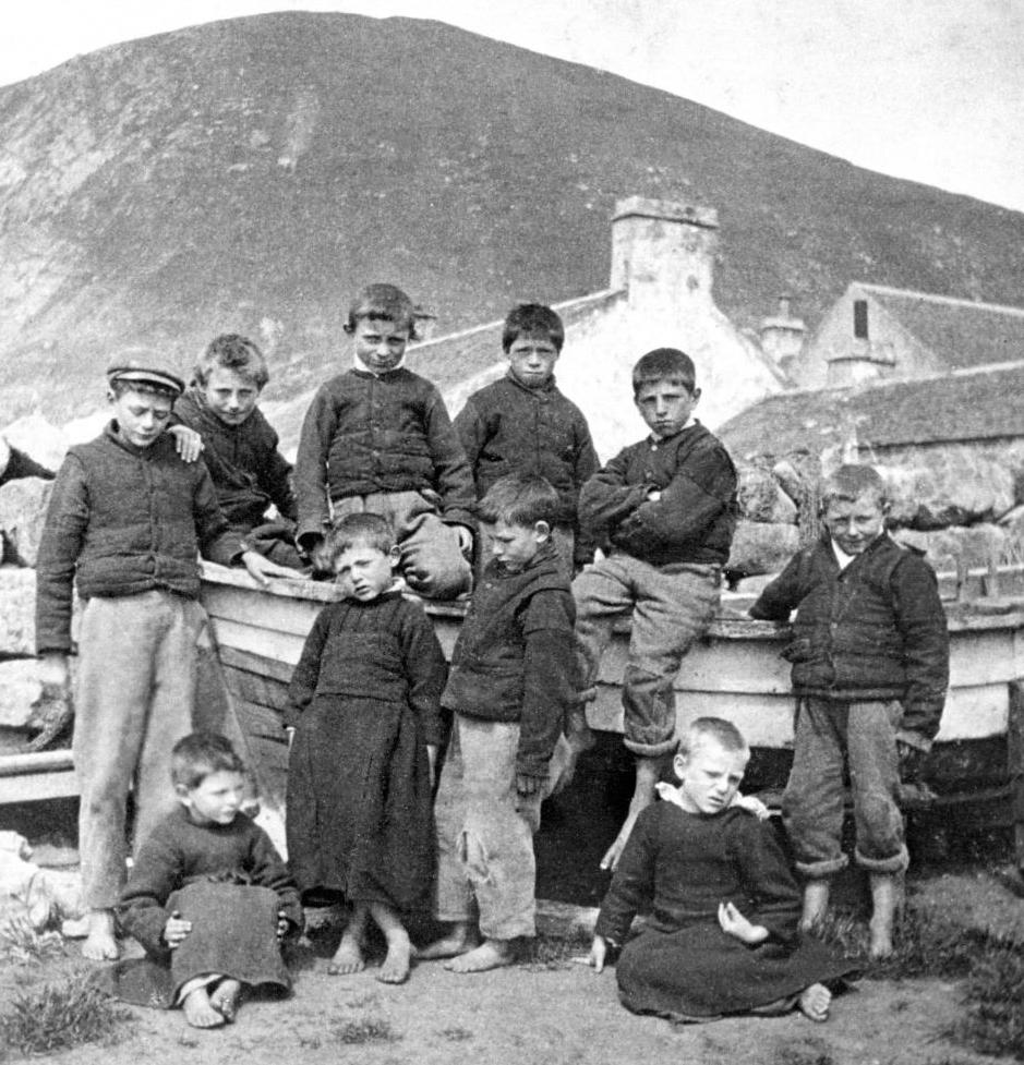
The Scottish islands are mostly located along the western coast, the Inner and Outer Hebrides. The Hebrides is an archipelago comprising hundreds of islands, both populated and unpopulated, off the northwest coast of Scotland. They are divided into two groups, depending on their distance from the Scottish coast. The Inner and Outer groups both have scenic, rugged landscapes, fishing villages and Gaelic-speaking communities. The Inner islands include Coll, Mull, Rum, Skye, and Tiree. The Isle of Skye is the most accessible as it is connected to the mainland by a bridge. There is a picturesque harbor at Portree and jagged 3,000-ft. peaks in the Cuillin mountain range. Most Gaelic speakers are today confined largely to the Islands in the west with a particularly important Gaelic stronghold in the Outer Hebrides. The remoteness has allowed th Gaelic speaking communities survive. The main Outer islands include Barra, Benbecula, Berneray, Harris, Lewis, North Uist, South Uist, and St Kilda. We see a group from Barra in the Outer Hebrides. Barra is the most southerly of the inhabited islands in the Outer Hebrides. Studio portraits like this are indistinguishable from mainland Scotland or for that matter England. Once we begin to get amateur snapshots around the turn-of-the 20th century, we do begin to see differences.
The Scottish islands are mostly located along the western Atlantic coast. The Hebrides are a vast archipelago off Scotland's west coast consisting of over 500 islands. There are both populated and unpopulated islands. They are divided into two groups, depending on their distance from the Scottish coast. They are divided into the Inner and Outer Hebrides, separated by the Minch--a 110km-long, 25–45 mile wide strait. The Inner and Outer groups both have scenic, rugged landscapes, fishing villages, white-sand shell beaches (machair), peat bogs. and Gaelic-speaking communities. They are shaped by a bracing Atlantic, maritime climate, moderated by the Gulf Stream. The Hebrides are known for The Outer Hebrides, or Western Isles, whih extend further into tyhe North Atlantic and stretch some 200 km north-to-south, characterized by a wilder, more westerly, and sparsely populated geography compared to the Inner Hebrides. The main Outer islands include Barra, Benbecula, Berneray, Harris, Lewis, North Uist, South Uist, and St Kilda. The Inner islands include Coll, Mull, Rum, Skye, and Tiree. The Isle of Skye is the most accessible as it is connected to the mainland by a bridge. There is a picturesque harbor at Portree and jagged 3,000-ft. peaks in the Cuillin mountain range. Mineral resources are limited, nut there is a valuable peat resource. The most valuable resouce is the sea providing both coastal and marine resources. The sea provide vital fishing (salmon, shell fish) and seaweed harvesting for biofuels, animal feed, and agricultural fertilizer. There is also efforts ro develop renewable energy (wind, hydrogen, and tidal technologies. The economics of these technologies are proving more challenging than once believed. There are important seabird breeding seabird colonies, seals, red deer, and otters.
The history of the Inner and Outer Hebrides are tied together. Obviously any people that could cross the English Channel and reach the British Iles has the technological capacity to reach these islands from the western coast of Scotland. The Hebrides are believed to have been settled at a fairly early point in the settlement of the British Isles. Some archeologists believe that this was the Mesolithic era or middle stone age or about when the Agricultural Revolution began. Some estimates suggest (8500-8250 BC). This was when the climatic conditions warmed enough to permit human settlement. Some of the neolithic structures have been provisionally date (3000 BC). This includes the standing stones at Callanish, but there is disagreement among archeologists. Little is known of the people who first settled in the Hebrides but they were surely the same people who settled Scotland as a whole. Settlements at Northton, Harris, include both Beaker and Neolithic dwelling houses. These are believed to be the earliest in the Western Isles, attesting to the settlement. Early history is largely unknown. We know that the islanders were speaking Gaelic at the time of the Roman conquest (1st century AD). The Christianization of Scotland began primarily from Iona in the Inner Hebrides. The two island groups shared the wrath of the Norsemen. The islanders suffered terribly from Norse raids (late-8th century). They became controlled by the Norse (9th-12th centuries). Somerled, a Gaelic Lord led a rebellion that through off Norwegian rule, founding the lordship of the Isles. The Lords of the Isles maintained effective rule over the islands through much of the rest of the medieval era. the late Middle Ages, and the kingdom of Scotland did not establish control over the islands for several centuries. The Kingdom of Scotland gained control (1493). From this point thy begin to have a common history with Scotland.
We have no idea what the Hebrides and the other islands were like before the advent of photography. There may have been some paintings, but we do not yet have any examples. Photography was invented in France (1839). It gook some time to make it to the islands. We do have some photographs from the late-19th century. We are not sure who took the photograph here about the turn-of-the 20th century (figure 1). An American folklorist and photographer, Margaret Fay Shaw, was active a few decades later.
There are some notable clothing trends here. First is that the younger boys are wearing flannel dresses. This is similar to isolated areas in Ireland where boys at the time were also wearing flannel dresses. It was said this was to prevent the faeries from kidnapping little boys. We suspect this was also the case in the Scottish Isles. Second, is that the boys are all barefoot despite the cool temperatures in Scotland. The girls also went barefoot. We suspect at the time that the boys did not get shoes until they were old enough to get jobs and purchase them. Third, the boys are all wearing long pants despite the fact that boys in Scotland at the time were increasingly wearing knee pants or short pants. Fourth, notice that kilts were not worn on the islands. We are not sure why that was, probably the Irish influence was stronger than the Scottish influence.
Inner Hebrides are islands off the western coast of Scotland. The Inner Hebrides are very close to the coast. Skye is close enough for a bridge connection with the mainland. They 79 Inner Hebrides islands stretch 150 miles from Skye in the north to Islay in the south. Many are uninhabited. They are are separated from the more distant Outer Hebrides (often referred go as the Western Isles) by the Little Minch -- an Atlantic Ocean sea channel and the Sea of the Hebrides. The largest Inner Hebrides islands are Skye, Mull, Jura, and Islay. The chain is divided into two groups, North and South. The southern group includes Mull, Islay and Jura. The Northern group is Skye and some smaller islands. The Inner Hebrides are today rather inexplicably split between Scottish shires, Inverness-shire and Argyllshire. The Isle of Skye is the most accessible and has a picturesque harbor at Portree and jagged 3,000-ft. peaks in the Cuillin mountain range. Jura is mountainous, bare and basically infertile. There is a large area of blanket bog. Much of the island is now a wonderful nature preserve. There is a large population of red deer. The dear browsing, the deer prevent the vegetation from turning back to woodland. Jura is also notable for its bird life, and especially for its raptors. Iona is located off the southern projection of the Isle of Mull has a particularly notable history. St. Columba who came to Iona began the Chriistianization of Scotland (563). The historic Abbey has been restored. It is one of the most important early Christian centers in Western Europe. In addition to spreading Christianity, the Abbey was the foundation of a monastic community by St. Columba. Saint Aidan served as a monk at Iona, before helping to reestablish Christianity in Northumberland beginning with Lindisfarne. The Abbey became a spiritual home of the Iona Community, an ecumenical Christian religious order now centers in Glasgow. The Abbey today remains a popular site of Christian pilgrimage.
Although called the Hebrides, the Outer Heberies are in reality significantly separated from the Inner Hebrides. They extend further north than the the Inner Hebrides. The Outer Hebrides stretch some 130 miles from Lewis in the north to the island of Barra in the south. The island group form a crescent about 40 miles from the Scottish mainland, farther off shore than the Inner Hebrides. The Outer Hebrides are separated from the Inner Hebrides by the Minch and Little Minch channels in the north and by the Sea of the Hebrides in the south. Many of the smaller islands are uninhabited. Most of the population live on Lewis and Harris. The population declined considerably in the 20th century. As connections increased which the mainland, the islanders became aware of the far greater economic opportunities off the islands. St. Kilda was even abandoned. This interconnected chain of Atlantic islands has appeal for people who really want to get way from civilization. The islands offer neolithic stone structures, medieval churches and even of all things mummies. The most notable site is the neolithic Calanais Stone Circle on Lewis. The Celtic roots run deeper here than anywhere in Scotland. It can be enjoyed today in language, arts, and music. Most Scottish Gaelic speakers are today confined to the Western Isles, especially in the Outer Hebrides, one of the few areas in Scotland where Gaelic is still spoken as the everyday language. The remoteness has allowed the Gaelic speaking communities survive. The main Outer islands include Barra, Benbecula, Berneray, Harris, Lewis, North Uist, South Uist, and St Kilda--a real outlier. The other islands are located close together. St. Kilda is located far out into the North Atlantic. We see a group from Barra in the Outer Hebrides. Barra is the most southerly of the inhabited islands in the Outer Hebrides. Studio portraits like those on the previous page are indistinguishable from mainland Scotland or for that matter England. Once we begin to get outdoor photographs and amateur snapshots around the turn-of-the 20th century, we do begin to see differences. We note portraits from South Uist, Agnes MacDonald and John Angus MacDonald.

Navigate the Boys' Historical Clothing Website:
[Return to the Main Scottish regional: Island page]
[Return to the Main Scottish regional page]
[Return to the Main Scottish page]
[Introduction]
[Activities]
[Biographies]
[Chronology]
[Clothing styles]
[Countries]
[Bibliographies]
[Contributions]
[FAQs]
[Glossaries]
[Images]
[Links]
[Registration]
[Tools]
[Boys' Clothing Home]
Navigate the Boys' Historical Clothing kilt pages:
[Main kilt page]
[Kilt suits]
[Scottish kilts]
[Scottish boys clothing]
[Scottish school uniform]
[Highland dance]
[Pipeband]
[Irish kilts]
[Irish boys clothing]
[Irish step dancing]
[Greek kilts]