**
World War II Liberation of the Netherlands Allies southern Netherlands
World War II: The Allies Reach the Dutch -- Liberating the Southern Netherlands (September 1944)
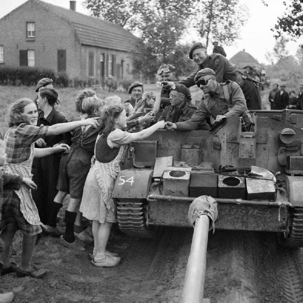
Figure 1.-- A carrier crew of 8th Rifle Brigade here is handing out the chocolate in their rations to Dutch civilians during the advance of the 11th Armoured Division in the southern Netherlands (September 22, 1944). The location is not indicated, but looks like a small rural village. It would have been somewhere south Hertogenbosch and northwest of Maastrict. Notice the wooden shoes. The vehicle is a Universal Carrier, often referred to as a Bren Gun Carrier, for the light machine gun with which early versions were equipped. The carrier here has the front armament removed. We think they are part of an advancing column with an artillery piece (probably a 25lb gun) being towed by a truck ahead of them--probably an American-built duce nd a half. The photograph was tarn by Sgt. Laing, No 5 Army Film & Photographic Unit. Source: Imperial War Museum.
The Netherland proved a tougher nut for the Allies than Belgium. Most of the Netherlasnds is located north of the Rhine and Rhine was amajorobjective. Th liberation ofthe Netherlands, however, began with crossing of the Meuse. The southern Netherlands included an unusal projection into norther Belgium -- southern Linburg including Masstrict. This projected separated northgern Belgium from Germany, significantly reducing the length of the Belgian German border. It was an artifact of the Dutch War of Independence. The Spanish Catholic armies that retook the southern Netherlands and reinstituted Catholocism, were unable to take Maastricht. The American Army crossed the Dutch border near Maastricht from Belgium. The American 30th Infantry Division liberated Maastrict (September 13-14, 1944). The Americam Army managed to to liberate large areas of southern Linmburg, this only slowed when they reached the 'waistline' of Linburg. The Allied focus was, howeve, to the east where they saw a way of reaching the Rhine. Gen Eisenhower gave Field Marshall the green light and supply priority for a dash to the Rhine. The effort was known as Operation Market Garden. The American and British dash to the Rhine as part of Market Garden to drive north on a very narrow front. Significnt parts of the southern Netherlands were thus not immediately liberated. Market Garden was designed to open a narrow salient between Eindhoven and Nijmegen. The units not directly in Market Garden began widening the Allied salient to begin the libertion of towns and villages in the south. British 11th Armoured was not committed to Market Garden push. It was ordered to protect the right flank of the Operation. It was attached to VIII Corps and began moving the day after Market Garden was launched (September 18). They advancing in two columns and linked up with the American 101st Airborne Division at Nuenen. Then 11th Armoured engineers established a bridge over the Willemsvaart Canal (September 22). The Division threaten to encircle Helmond, forcing the Germans to withdraw (September 25). With the failure of Market Garden, the Allied forces in the Netherlands focused on routing out the Germans still south of the Rhine, primarily Zeeland, North Brabant, and norherrn Linburg. Market Garden cut through North Brabant. There were also slivers of South Holland and Gekerland.
Geography
The Netherland proved a tougher nut for the Allies than Belgiumwhich theGermansunexpectedly withdrewwithout much of a fight. A factor here was the unexpected collapse of the German Army in France. The Germans in Belgium believed NAZI propaganda that the Allies were making slow progress to the south in France. When the breakout came, they were unprepared. The Netherlands is flast, but the rivers that run through provide defensible barriers. The Rhine is the major river of northern Europe. It rises in Switzerland and runs north, forming a east-west barrier between France and Germany. When in reaches the Netherlands it turns west, creating a north-south barrier. Most of the Netherlands is located north of the Rhine, but three provinces (Zeeland, North Brabant, and Linburg) are located to the south (Dutch province map). Small parts of South Holland and Geklerland are located south of the Rhine. The Rhine was a major objective for the Allies. The River was the last important geographical barrier into the Reich. An army that crossed the Rhine in the Neetherlands had an unobstructed path into the Reich. And while the Germans were reluctntly willing to withdraw from Belgium, they were not going to abandon the Rhine barrier.
The liberation of the Netherlands began with crossing of the Meuse. The southern Netherlands included an unusal projection into northern Belgium -- southern Limburg including Masstrict. The province nasmes can be a little confusing. Many have north and south names like North Barbant or South Holland. In this case we are talkibng about the southern areas of Limburg Province, there was no North and South Limburg. The southern area of Limburg projected far to the south of the rest of the Nettherlands. This projected was located east of the Meuse. As a result, southern Limburg separated northern Belgium from Germany, significantly reducing the length of the Belgian-German border. It was important in World War I as Germany respected Dutch neutrality, but not in World War II as Germany invaded, both Belgium and the Netherlands. This southerly projection was an artifact of the Dutch War of Independence. The Spanish Catholic armies that retook the southern Netherlands and reinstituted Catholicism, were unable to take Maastricht. In medieval times, the province was strategic with trade routes connecting Masstricht, Aachen, and Cologne. The American Army crossed the Dutch border near Maastricht from Belgium. The American 30th Infantry Division liberated Maastrict (September 13-14, 1944). The Americam Army managed to to liberate large areas of southern Linmburg, all thewayto Hoensbroek with its historic castle. The liberastion of Limburg only slowed when the Americans moving north reached the 'waistline' of Limburg. Just south of Limburg lies Aachen--the first German city to fall to the Allies (October 21). The Americasns had to fight a costly 19-day battle to take the city. After the rapid advance through France, the chastened Americans began to ask if the Germans were going to resist so fiercely city by city.
The Allied focus was not east to Linburg, but north to the Rhine. Field Marshal Montgomery saw a way of reaching the Rhine. Gen Eisenhower gave Field Marshall the green light and supply priority for a dash to the Rhine. The effort was known as Operation Market Garden. The American and British dash to the Rhine as part of Market Garden to drive north on a very narrow front. Significnt parts of the southern Netherlands were thus not immediately liberated. Market Garden was designed to open a narrow salient between Eindhoven and Nijmegen. The units not directly in Market Garden began widening the Allied salient to begin the libertion of towns and villages in the south. British 11th Armoured was not committed to Market Garden push. It was ordered to protect the right flank of the Operation. It was attached to VIII Corps and began moving the day after Market Garden was launched (September 18). They advancing in two columns and linked up with the American 101st Airborne Division at Nuenen. Then 11th Armoured engineers established a bridge over the Willemsvaart Canal (September 22). The Division threaten to encircle Helmond, forcing the Germans to withdraw (September 25).
With the failure of Market Garden, the Allied hope of crossing the Rhine and ending the War before Christmas ended. The Allied forces in the Netherlands setabiut on routing out the Germans still south of the Rhine. This meant primarily Zeeland, North Brabant and northern Linburg. Market Garden cut through North Brabant, but the Germans still controlled substantial areas of the province. There were also slivers of South Holland and Gekerland located south of the Rhine. Of course the cut off German units in the wesrtern areas could only holdout so long without reenforcements and supply. Insteadoffighting, many oftheGermansherechoseto movenorth across the Rhine which stopped the Allies. The Germans in the western areas of the Netherlands adjacent to the German Rhineland could continue resisting and holdout longer.

