
World War II Pacific Island Territories: The Marianas--The Archipelago
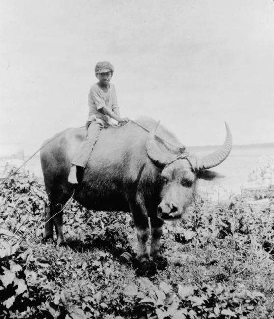
Figure 1.-- Guam was a Spanish colonial possession acquired by the United States in the Spanish-American War (1898). Spain had previously sold the other Mariana islands to Germany. This photograph was taken by an American on Guam in 1919, just after World War I when Japan acquired the other Marianas Islands. A Chamoro boy rides the family water buffalo near Sumay village.
|
|
The Marianas is an important Micronesia archipelago in the central Pacific Ocean between the 12th and 21st parallels north and along the 145th meridian east. The Northern Marianas consists of 14 tropical islands stretching across 400 miles. They are adjacent to the Marianas trench which is the deepest point in the ocean. The islands are volcanic formations, in fact the summits of volcanic mountains in the north-western Pacific. Saipan is the most populated island in the group. Tinian is a smaller island near Saipan. Rota to the south is much less developed. The southern-most island is Guam. The war developed somewhat differently on the islands because Guam was separated from what became known as the Northern Marianasa (Rota, Saipan, and Tinian). The other islands are much smaller and of lesser importance.
Guam was a Spanish colonial possession. As part ofSpanish colonial policy to subdue and Christanize the native Chamoros in the Marianasa, most of the Chomoros were resettled on Guam. Guam was separated from the rest of the Marianasa which came to be known as the Northern Amarianas as a result of the Spanish-American War. Guam was located to the extreme south beyond Rota. The Northern Marianas were purchased by the Germans and then seized by the Japanese in World War I. The United States in the Inter0War era did not foirtify Guam. The Japanese in violation of treary obligations did fortify the Northern Marianasa. The Japanese strike on Pearl Harbor imobilized the U.S. Pacific Fleet (December 7, 1941). Three days later a heavily armed Japanese invasion force overwealmed the small American garrison (December 10). Unlike Saipan to the north, there was no Japanese population on Guam, but a substantial Chomoro population which suffered under the brutal Japanese occupation. The American offensive in the Central Pacific finally reached the Marianasa (June 1944). The Americans struck first at Saipan and when the Imperial Fleet intervened, its fleet arms was badly damaged in the Battle of the Philippine Sea (June 1944). Once the Japanese were defeated on Saipan, the Amerians invaded Guam. In the fierce fighting that followed, the Jpanese fought to the death and the island heavily damaged. After securing the iskand, it was turned into a forwatd supply base to support both naval and air operations against the Japanese.
Rota
Rota was part of the Japanese-controlled Northern Marianas Mandate. It was, however, located further south thann the other Japanese-controlled islands, about equal distance between Saipan and American-controlled Guam. Rota is approximately 11 miles (17 km) long and 3 miles (5 km) wide. The highest point on the island is Mt. Manira which is 1,625 feet (495 m) high. Songsong village is the largest and most populated followed by Sinapalo village (Sinapalu). The surrounding coiral reef and lack of a good harbor spared isolated Rota from heavy fighting. It meant that meant that the island was not as valuable militarily as Saipan. Thus the Japanese did not heavily fortify and defend the island. Rota was used by the Japanese as an air supply link. They built a single air strip on the Rota. Rota is now known as the "peaceful island" because it was not a major World War II battlefield.
Saipan
Saipan is the largest island in the Marianas Archipelago. It is located at latitude of 15.25° north and longitude of 145.75° east, about 200 km (120 mi) north of Guam, the oter major island in the Marianas. The island is about 20 km (12.5 mi) long and 9 km (5.5 mi) wide. The western side of Saipan has sandy beaches and an offshore coral reef, creating a large lagoon. The eastern shore in contrast is has rugged rocky cliffs and another offshore reef. The highest point on the island is a limestone covered peak called Mount Tapochau 474 m (1,554 ft). Locted to the north of Mount Tapochau towards what is now known as Banzai Cliff is a ridge of hills. Mount Achugao, about 2 miles North, unlike Mount Tapochau, Mount Achugao is an extinct Volcamo. The indigenous population is the Chamorros. Saipan was the largest island of the Japanese mandate of the Northern Marianas acquired as a result of World War I. Japan brought in large numbers of immigrants which swaped the indigenous Chamorro populastion. The Japaneserequired the Chamorros to learn Japanese. The schools were taught in Japanese. As a result, at the time of World War II, Japan was essentially a Japanese island. It was thus the first island the United States encountered with any number of Japanese civilians. Japan turned Saipan into one of the most heavily fortified bases in the Pacific and for good reason. Saipan took on major importasnce in the Pacific War. The United States built the long-range B-29 bomber which had the capacity to reach Japan from the Marianas.
Tinian
Tininana was part of the Japanese mandate of the Northern Marianas. It is a coral island 16 km (10 mi) long and 6 km (4 mi) wide. There were herds of wild cattle and ancient ruins, consisting of two rows of truncated pyramids built of masonry.
It was primarily used for sugar plantations. Tinian is a small island located about 5 miles off Saipan. Taipan did not have a substantial population. It was flat and thus provided a good place to build airfields. The Japanese built three there and were contructing a fourth at the time of the American invasion.
CIH

Navigate the Children in History Website:
[Return to Main World War II Marianasa page ]
[Return to Main World War II island territory page ]
[Return to Main World War II country page ]
[Return to Main Marianasa history page]
[About Us]
[Activities]
[Chronology]
[Clothing styles]
[Countries]
[Debate]
[Economics]
[Garment]
[Gender]
[Hair]
[History]
[Home trends]
[Literary characters]
[School types]
[Significance]
[Transport and travel
[Uniform regulations]
[Year level]
[Other topics]
[Images]
[Links]
[Registration]
[Tools]
[Return to the Historic Boys' School Home]
Created: 11:23 PM 8/11/2008
Last updated: 10:17 PM 6/14/2009
align=right>