English Seaside Resorts: Gordon Beach
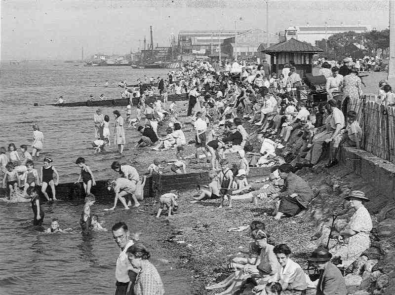
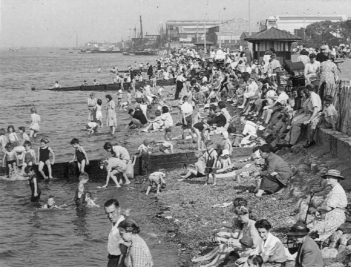
Figure 1.--We note a scene at Gordon Beach in 1950. It shows children's beachwear at the time. Notably many younger boys had bib-front suits. The children are mostly paddling in the water. We don't see many simmers. The cold water of course is a factor. A reader has helped locate the beach along the Thames at Gravesend/Rochester region. This is in the tidal region of the Thames about 30 miles from London on the south shore. It looks to be a working-class beach, perjaps day trippers from London or locals. Notice all the prams. Click on the image for an enlarged view.
|
|
We note a scene at Gordon Beach in 1950. The tide is in so the water is very near to the beach barrier. The photograph shows children's beachwear at the time. Notably many younger boys had bib-front suits. The children are mostly paddling in the water. We don't see many swimmers. The cold water of course is a factor. And southern England has the warmest water off Britain. Some girls looke to be wearing romper suits, but thy may have just hiked up their dresses.
We were not sure just where Gordon Beach was located. It seems a rather industrial area. It looks to be a working-class beach, perhaps day trippers from London or just locals on a warm summer day. Notice all the prams. Hopefully our British readers will know more.
One reader writes, "I wonder about the Thames Estuary as there are shingle beaches along there on both the North and
Siouth Banks in some places. As you say the populace looks working class, so they may well be daily trippers from the East End of London. There are no beach huts which would have pointed to an established seaside resort.
Having studied this photograph more carfully, I think it is along the Thames at Gravesend/Rochester region. This is in the tidal region of the Thames about 30 miles from London on the south shore. I think the sign
on Warehouse reads Saandford Marine Engines. There is a Gordon Promenade in Gravesend just down stream from the Port of London Authority Offices. It would be logical to call the shore at that point Gordon Beach. The objects in the distance look like river architecture (piers, mooring stations etc.). I think the boats moored in the foreground may be Thames barges. I found a map showing the Promenade which adjoins a recreation ground, making access to the 'beach' very easy. Looking again at the photo with the map it all fits nicely I think."
Thames Estuary
The Thames is Britain's most important river leading as it does to London. The city in fact began as a Roman military camp and bridge across the Thames. The Thames is a highly tidal river. The tides introce a volume of water into the Thames estuary vastly greater than the actual riverine water. Thus there is a huge difference in the warer level between high and low tide. Here we see high tide. At low tide the children would have had a substantial expanse of sandy mud flats where they coulf play. Tis opened London to great tidal suges and storms in the North Sea. Today the Thames Barrier protects the city.
General Charles "Chinese" Gordon (1832-83)
General Gordon made a name for himself in China during the Second Opium War (1860s). He next commanded the Royal Engineers in their wirk around Gravesend (1871), He was asked to oversea the rebuilding of two forts. Shornmead, 4½ KM down river from Gravesend and
Coalhouse Point across the river at Tilbury. Both forts had fallen into disrepair at the end of the Napoleonic Wars at Waterloo (1815). The rise of Louis Napoleon in France (1849) caused some concern in Britain. The rise of French Nationalism concerned British officials and the states of British defenses were reviewed. The renewal of these fortifications protected against seaborne attack up the Thames. Forts were modernized or rebuilt, both in the Thames estuary and along the Channel. He was involved in the tail end of this project. The French defeat by the Germans (1870-71), substantially reduced British concern with the French. Subsequently Gordon worked for the Khedive in Egypt and Sudan and was involved in supressing the slave trade. Gordon's role in this fort project and highly publicized demise in Khartoum (1883) was presumably why the beach was named for him.
The Forts
Marshy ground caused great problems with subsidence at Shornemead and I don't think it was ever operational. It stayed as a half completed defence with some repair until the end of World War II and was then used as target practice by the Rotal Engineers and is now a ruin. There are still some parts that find fascination for archeologists. Coal House Point Fort across the river was a much more substantial defensive position. It still stands and is a favourite picnic site allowing grand views of the Thames.
Chronology
We are not sure just when Gordon Beach became popular, presumably about 1885. This suggests that the site was aopular beach before that. We note a scene at Gordon Beach in 1950. The tide is in so the water is very near to the beach barrier. The photograph shows children's beachwear at the time. Notably many younger boys had bib-front suits. The children are mostly paddling in the water. We don't see many swimmers. The cold water of course is a factor. And southern England has the warmest water off Britain. Some girls looke to be wearing romper suits, but thy may have just hiked up their dresses.
Location
We were not sure just where Gordon Beach was located. It seems a rather industrial area. It looks to be a working-class beach, perhaps day trippers from London or just locals on a warm summer day. Notice all the prams. Hopefully our British readers will know more.
One reader writes, "I wonder about the Thames Estuary as there are shingle beaches along there on both the North and
Siouth Banks in some places. As you say the populace looks working class, so they may well be daily trippers from the East End of London. There are no beach huts which would have pointed to an established seaside resort.
Having studied this photograph more carfully, I think it is along the Thames at Gravesend/Rochester region. This is in the tidal region of the Thames about 30 miles from London on the south shore. I think the sign
on Warehouse reads Saandford Marine Engines. There is a Gordon Promenade in Gravesend just down stream from the Port of London Authority Offices. It would be logical to call the shore at that point Gordon Beach. The objects in the distance look like river architecture (piers, mooring stations etc.). I think the boats moored in the foreground may be Thames barges. I found a map showing the Promenade which adjoins a recreation ground, making access to the 'beach' very easy. Looking again at the photo with the map it all fits nicely I think."
A British reader tells us about the current status of Gordon Beach. "I was at a loose end last evening and drove to Gravesend to find Gordon Beach. I was successful. Being about 7.45pm when I took the photo, there were of course no swimmers, however the scene has changed a bit. The roofed shelters along the promenade have gone, but the wharfs and
moorings beyond are still there. There is quite a bit of sand beyond the shingle. The tide was coming in when I was there but nowhere near as high as in the 1950 photo. The park is very much reduced in size having been built over.
There is a well equipped children's play ground with swings and roundabouts. There were quite a few children there enjoying the fine evening.
>>
HBC

Navigate the Boys' Historical Clothing Web Site:
[Return to the Main English seaside resorts page]
[Introduction]
[Activities]
[Biographies]
[Catalogs]
[Chronology]
[Clothing styles]
[Countries]
[Girls]
[Literary]
[Bibliographies]
[Contributions]
[FAQs]
[Glossaries]
[Images]
[Links]
[Registration]
[Tools]
[Boys' Clothing Home]
Navigate the Boys' Historical Clothing Web Site:
[Sailor suits]
[Sailor hats]
[Buster Brown suits]
[Eton suits]
[Rompers]
[Tunics]
[Smocks]
[Pinafores]
Created: 6:36 AM 5/21/2009
Last updated: 2:54 AM 5/26/2009