|
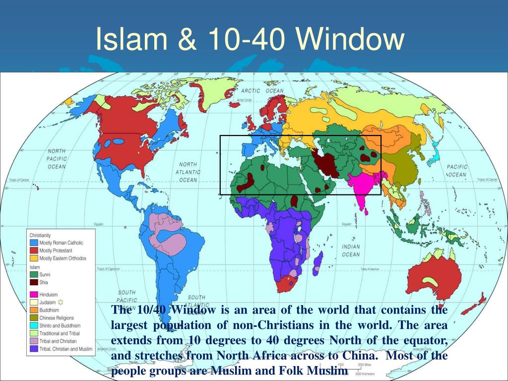
The accident of geography limited the spread of Islam to a relatively narrow east-west corridor--10/40 band. It is a rectangular geographic band spanning from 10° to 40° North latitude. It stretches horizontally across North Africa, the Middle East, Central and South Asia, extending from the North Africa Atlantic Coast all the way to Bay of Bengal. Central Asia is a large Muslim area, but an area with rekatively small populations. This is largest concentrations of the world's Muslim as well as Hindu populations. There is also an Oceanic Muslim isolate thay needs to be considered. Mulim Arab traders skirted the Buddhist/Hind state in Southeast Asia and brough Islam to Oceania. And thus Islam resurfced then resurfaces in Oceania (Malaysia. Indonesia, and the southern Philippines). his occurred just before the arrival of Europeans and Christianity. The great majority of Muslims live in the 10-40 box, but Indonesia is he most populace Muslim mjority country. The Oceanic isolate does not face the arid conditions of the 10-40 box, butvthere are major problems here as well. As to why he Muslim 10-40 box is so dry, the Middle East and North Africa is naturally hot and arid due to a combination of geographic location, atmospheric circulation, and geological factors. The primary reason is that most of the Arabian Peninsula and North Africa lie within the global subtropical high-pressure belt creates a dome over the region. Within this dome, the air falls, warms up, and dries out. This falling vertical motion suppresses cloud formation and thus rainfall, creating very stable, dry conditions. Another very important facyor is that the region is surrounded by seas — the Mediterranean Sea, the Red Sea, Arabian Gulf, and Arabian Sea — but the long distances inland limit the reach of moisture-laden winds. Atmosperic masses tend to lose moisture before reaching the interior, and the Indian Ocean monsoon system only reaches the southern fringes of the Arabian Peninsula. This is becuse the Indian Sub-continent blovks the Bay of Bebgal monsoons and the high pressure dome over the Levant and easterrn Middle East blocks the Arabian Sea monsdoonms. There are several other natural factors involved, including rain shadow effects and geological conditions. The only Muslim mjority country to benefit from Indian Ocean monsoon rains is Banladash which has a climate more like Southeast Asia than South Asia. Climate change, especially rising tempeatures is now making these conditions increasingly extreme, leading to severe water stress and major environmental challenges. Tragically the goverrnments of Muslim majority countries are pursuing poliocy chioices making tghe situatioin even more severe.

Navigate the Historic Boys' Clothing Web Site:
[Return to the Main Muslim 10-40 Box page]
[Return to the Main Islam page]
[Return to the Main Middle Eastern chronologies]
[Return to the Main climate page]
[Introduction]
[Activities]
[Art chronologies]
[Biographies]
[Chronologies]
[Clothing styles]
[Countries]
[Bibliographies]
[Contributions]
[FAQs]
[Glossaries]
[Images]
[Links]
[Registration]
[Tools]
[Boys' Clothing Home]