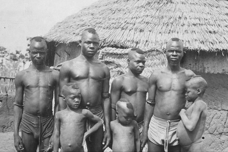
Figure 1.--This photograph was taken in 1910 in Boayini, part iof the British Gold Ciast colony, now a town in northern Ghana. It depicts a group of boys belonging to Mamprusi ethnicity. Note the destictive hair cuts. The younger boys are unclothed while the teenagers have diucarded their raditional loincloths for European shorts.
One of the tribal groups of northernn Ghana and Togo are the Mamprusi/Mampruli. Although not a majority, they are the akrgest sungke ethnic group in the north. The Mamprusi kingdom is one of several related states founded by descendants of Na Gbewa -- a parially legendary figure (13th century). Na Gbewa had founded the Kingdom of Dagbon, in modern northern Ghana. The Kingdom of Dagbon is one of the oldest and most organised historic traditional kingdoms of Ghana. The sons and daughters of Na Gbewa are seen as founding other states, including the Mamprusi Kingdom. The Mamprusi Monarchy was founded by a great warrior named Tohazie the Red Hunter--red because of his fair complexion. The Marpusi fought other tribal grouos to protect their trade in slaves and other products, contracting mercinaries from the west -- modern Ivory Coast (18th century). Then in the19th century the Eutopeans began to expand theur control bryind the ciast--moving north. The Mamprusi are part of the Mole-Dagbani ethnic group, related to the Moshi, Nanumba, and Dagomba. The Mamprusi populatiin is about 450,000 people in Ghana and some 10,000 in neigboring Togo. The Mamprusi inhabit an area of northern Ghana between the White Volta and Nasia rivers. They view themselves as living a central palace and being more civilized than the surrounding universe of peoples surroundung them. Mamprusi lands are part of the climastic zone in the Guinea Savanna. This probably relects land better suited for agriculture than the surrounding area. The Mamprusi traditionally lived in circular compounds surrounded by their farmland. Marpusi settlements are clustered around the compound of the chief. The geological Gambaga escarpment formation reaches 450 meters above sea level at the southward bend of the White Volta River, and continues eastward into neighboring Togo. Historians believe that in the pre-colonial period, the Mamprusi controlled an area this escarpment. The area to the south of the Gambaga scarp, there wooded slopes. This contrasts with the arid land and lathyritic soils to the north. There was a deforested area along the scarp to the northwest. To the south, southeast, and west, the land is periodically flooded by tributaries of the Nasia, Oti, and Volta rivers. The Mamprusi toward the end of the colonial period, was the northern margin of the yam-growing region of Ghana. This was a very important crop. Deforestation, droughts, and population growth has damaged the economy. Yams yields have declined. Farmers are letting their land lie fallow less and there is less uncultivated land.
Sources
Ade Ajayi, J. F.and Michael Crowder. History of West Africa 2nd ed. (Columbia University Press: 1976).