
Ghana: Geography
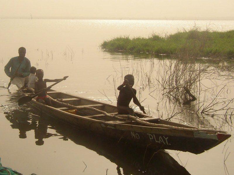
Figure 1.--The photo was taken in Adape in north-central Ghana about 2011. Ghana is facing increasing probles with drought and desertification in the north, but there are any well-watered areas. There are reports of children at Adape being forced into dangerous and phyically deanding lbor in Adape and prevented from going to school.
This is a photographic evidence of the children prevented from going to school and forced to work in the fishing (in the foreground we can see some nets). The first boy does not have any clothese because he is required to dive. We are not sure if this should be classified child labor or slavery. Notice the nane of the canoe, 'No Play'.
|
|
Ghana is a West African country bordered by Togo and the Ivory coast on the west and east and Burkina Faso (once called Upper Volta) in the north. The country is located just north of the Equaror in the Gulf of Guinea bite. There is a swampy coast with sandy ares backed by plains and scrub which is several small rivers and streams, for the most part navigable only by canoe. There are no major coatal indentations. The interior is forested and savana as one moves north. The terrain is mostly mostly low plains with dissected plateau in south-central area. The Kwahu Plateau in the south-central area is particularly important. A tropical rain forest belt in the south is broken by heavily forested hills with many mostly small streams and rivers. This is known as the Ashanti and extends northward from the coast near the eastern border with Côte d'Ivoire. About half of Ghana is only about 150 meters above sea level, making the country vulnerabe to flooding. The highest point is 883 meters. his area, known as the "Ashanti," produces most of the country's cocoa, minerals, and timber. North of this belt, the country varies from 91 to 396 meters (299 to 1,299 ft) above sea level and is covered by low bush, park-like savanna, and grassy plains. Lake Volta is a large river lake system in the central and southeastern area of the country. It is the world's largest artificial lake. Thee is a recurrent and worsening drought in the north. This has severely disrupte traditional agricultural activities, wiosened by deforestation; overgrazing. Soil erosion is another probem. Subsistence poaching and habitat destruction threatens wildlife populations. An increasing problem in the south is water pollution and inadequate supplies of potable water
CIH

Navigate the Boys' Historical Clothing Web Site:
[Introduction]
[Activities]
[Biographies]
[Chronology]
[Cloth and textiles]
[Clothing styles]
[Countries]
[Topics]
[Bibliographies]
[Contributions]
[FAQs]
[Glossaries]
[Images]
[Links]
[Registration]
[Tools]
[Boys' Clothing Home]
Navigate the Boys' Historical Clothing national pages:
[Return to the Main Ghana page]
[Return to the Main African country page]
[Return to the Main African page]
[Angola]
[Burkina Faso]
[Cape Verde Islands]
[Democratic Republic of the Congo]
[Ethiopia]
[Gabon]
[Ivory Coast]
[Lessotho]
[Madagascar]
[Mali]
[Somalia]
[South Africa]
[Togo]
[Uganda]
Created: 10:46 PM 12/2/2010
Last updated: 4:35 PM 11/27/2012