
Thai Geography
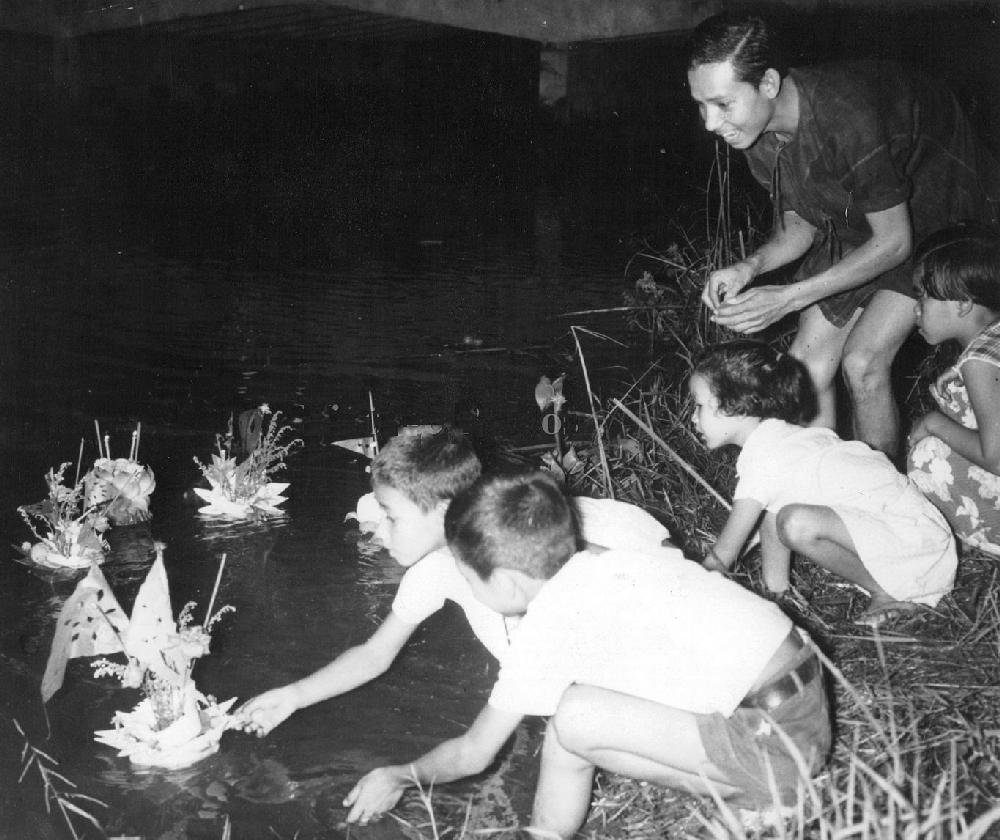
Figure 1.--The Indian Ocean Monsoon creates the rainy season in Thailand, although this varies somewhat seasonally. Loi Krathong is a Thai festival celebrated annually throughout Thailand. The name could be translated as 'to float a basket'. It comes from the tradition of making krathong or floating decorated baskets to be floated on a river. The press caption here reads, "When Rainy Season Ends: In thailand, one of the most enjoyable holidays for the adults and children is the Loy Krathong Festival. Here, afather watchesashischildren float their homemade krathongs, or boats, in a suburb of Bangkok."
|
|
Thailand is situated in the middle of Southeast Asia and borders on all the Southeast Asian countries except Vietnam. In the north Thailand borders on Myanmar and Laos. To the east it borders on Laos and Cambodia. In thesouth there is a Gulf of Thailand (ndian Ocean) coast and abirder with Malaysia. In the west there is an Andaman Sea (Indian Ocean) coast and Myanmar border. The country until the mid-20th century was known as Siam. The country's longest border is with Burma because the two countries share the northern streaches of the Malay Peninsula. Thai territory covers an area of 513,000 square kilometers. To the north it borders. Thailand has six geographic zones. different types of terrain.
Northerrn Thailand has high mountains which are the source of streams and rivers that feed into the Mekong, Chao Phraya, and Salawin Rivers. This is the region where the Wild Boaar soccer team boys got trapped in a cave by Monsoon rains (2018). Notable mountains in the area are Luang Phra Bang, Daen Lao, Thanon Thong Chai, Phee Pun Nam, Khao Khun Tan, and Phetchaburi. The highest mountain is Doi Inthanon in Chiangmai (2,565 meters).
The Central Plains are perhaps people think about when Thailand comes up. Here we find the densest and largest sediment plains in Thailand with elephants and other wildlife asociated with the country. The major rivers are the Chao Phraya, Mae Klong, Tha Jean, Pa Sak, and Bang Pa Kong Rivers. These rivers and the flat plains of central Thailand are the country's agricultural heartland. Bangkok is located along the coast in the Central Plains region close to the border with the eastern region.
The northeastern region (Isan) is the largest area. Plateaus are flanked on the western and southern edges by steep mountain ranges. The center of the region is the Korat Basin. The Chi and Moon are the rivers running through the region and like most important rivers in the region flow into the Mekong in Ubon Ratchathani. Peaks in the region are the Phetchaburi, Dong Phaya Yen, San Kampaeng, and Pha Nom Dong Rak .
Western Thailand is a more narrow region. Here there are small, slender plains and vallys between important mountains. The Thanon Thong Chai and Ta Naw Sri Mountains provide the run off streams that give rise to the Kwai Noi and Kwai Yai Rivers that flow into the southerly flowing Mae Klong River, a rare Thai river that does not flow into the Mekong.
Eastern Thailand has varied terraine. The north is dominated by high mountains and a coastal plains. In the east are river plains. The middle area consuists of a jagged sierra and rolling plains. The south is coastal plain. Between the Ban Tad and Chanthaburi Mountains is a narrow plain, ideal fruit production. The Bang Pa Kong River flows through the region into the Gulf of Thailand. The shoreline very is popular with tourists. It has lovely palm fringed beaches and just offshore are islands (Koh Chang, Koh Kood, and Koh Shi Chang).
Southern Thailand has mountains, plateaus, coastal, and islands. All of this is crammed into a narrow peninsula leading to Malaysia. Parallel eastern and western beach plains are divided by tall mountain ranges running down the center of the peninsula. Impressive mountains are the San Ka Ra Kiri (which borders Malaysia) Phuket, and Nakhon Si Thammarat. The rivers are morelikestreamsastheyrundown to theseaftom thenpintauns (Kra Buri, Trang, Kirirat, Ta Pee, Pak Panang, and Klok). Islands the east include Phuket and to the west Koh Samui and Koh Pha Ngan.
The climnate is tropical just morth of the equator. Only when you climb the major mountainsdo you emergefrom thetropics. The southern border touches on 6°N at the Malaysia border. Thailand can best be described as tropical and humid for the majority of the country during most of the year. The area of Thailand north of Bangkok has a climate determined by three seasons while the southern peninsular region of Thailand has only two. The dominate climatic phenomenon is the Monsoon rains which create a wet and dry seasonin thesouth. Further north the wet and dry seasons are less clearly defined, creating a third season. Preciptation levels are highest in the south.
HBC

Navigate the Boys' Historical Clothing Web Site:
[Introduction]
[Activities]
[Biographies]
[Chronology]
[Cloth and textiles]
[Clothing styles]
[Countries]
[Topics]
[Bibliographies]
[Contributions]
[FAQs]
[Glossaries]
[Images]
[Links]
[Registration]
[Tools]
[Boys' Clothing Home]
Navigate the Boys' Historical Clothing national pages:
[Return to the Main Thai page]
[Return to the Main Asian page]
[Afghanistan]
[Bangladash]
[Bhutan]
[Burma]
[China]
[India]
[Pakistan]
[Sri Lanka]
[Tajikistan]
[Turkmenistan]
[Uzbeckistan]
Created: 1:47 PM 2/15/2019
Last updated: 1:47 PM 2/15/2019