|
The huge size of New Zealand and the rugged terraine has significantly impacted the people living there. Since time memorial it was inhabited by stone age people with limited technology that has changed little for millennia. They were among the most primitive people on earth. The western half of the island was part of Dutch East Indies. The eastern half was nomially ruled by the Germans, English, and Australians. The colonial touch sas ligh and did nit go much beyound a few coasyal outposts. The various tribes had only local connections and war between them was endemic. The tribal warfare led to head hunting which until World War II is what the islands were best known for. The geography of the island meant that given the level of technology that any large political grouping was unlikely. The mountanous spine divided the island and the rugged interior impeded interactions on both sides of the the towering spine. Only with the coming of the Europeans did a form of wider political union develop which ultimately led to the modern split beteen the Indonesian comtrolled west and Papua in the east. The Indonesian west is Papua and Papua Barat (formerly West Irian Jaya). The now indepenent east and associated islands are Papua New Guinea. Tribal conflict still affects the entire island, but is a far cry from earlier eras.
The Dutch East Indies, were declared independent by Sukarno immediately after the Japanese surrender (August 1945). But the Dutch wanted to keep what they had (for more than 300 years). After a truggle Indonesia did become independent (1949). The Dutch kept New Guinea which they maintained should not be [art of Indonesia because of ethnic and cultural differences. We note the Dutch dchool still operating in 1960-61. The Indonesiana took possession of the region and it was named Irian Jaya. The Dutch citizens were forced to return to the Netherlands. The natives, the Papuas, have little in common with the other Indonesians and most want to be independent. There are not only ethnic, cultural, and religious differences, but under Indonesian rule the Muslim Javanese have the best jobs. The Papuans are basically second-class citizens.
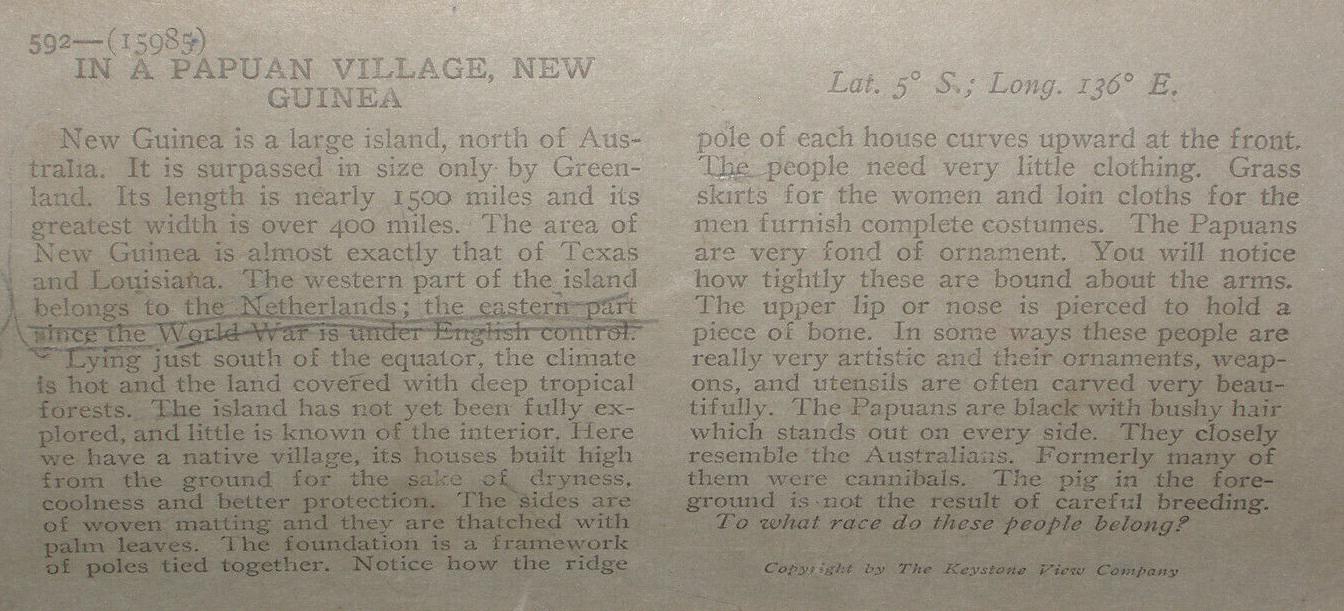
Papua New Guina is the eastern half of the island of New Guinea. This is the second largest island in the world. The central core od the island has a rugged mountenous spine, the Own Stanley Mountains. The population includes Melanesian, Papuan, Negrito, Micronesian, and Polynesian peoples. Britain and New Guina in the final era of colonial expansion divided eastern New Guina between Germany which received the the northern sector and Britain which received the southern sector (1885). Britain transferred responsibility for its sector to Australia in (1902). Substantial areas of the island well into the 20th century remained largely unexplored. Australian forces occupied the German sector during World War I (1914-18) and in the peace settlement the Germans lost all of their Pacific colonial posssions, some of which were transferred to Japan. Australia retained resonsibility for the former German northern sector which was united with the southern sector. New Guinea was the scene of bitter fighting during the Pacific War (1941-45). Japan seized the norther sector (1942), but after a series of stunning victories, a Japanese naval taskforce heading to seize Port Moresby in the south was turned back by the U.S. Navy at the Coral Sea (May 1942). Heavy fighting continued on the island throughout 1942 and 43. Australia continued to administer Papua New Guinea after the War until independence (1975). A number of islands to the east are part of New Guinea. Bougainville, another World War II battlefield, is one of those islands. A secessionist revolt (1988-97) resulted in the loss of 20,000 lives.

Navigate the Boys' Historical Clothing Web Site:
[Return to the Main New Guinea page]
[Return to the Main Oceania page]
[Return to the Oceania history]
[Return to the World War II campaign]
[Introduction]
[Activities]
[Biographies]
[Chronology]
[Cloth and textiles]
[Clothing styles]
[Countries]
[Topics]
[Bibliographies]
[Contributions]
[FAQs]
[Glossaries]
[Images]
[Images]
[Links]
[Registration]
[Tools]
[Boys' Clothing Home]