
Egyptian Geography: The Egyptian Sahara
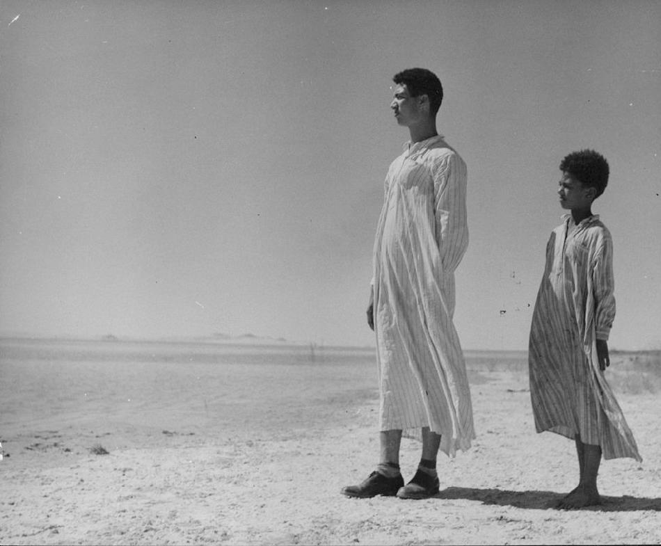
Figure 1.-- There are sand dunes in the Egyptian Sahara. This is the most dramatic feature, but is atypical. Most of the Sahara is rocky hamada, a type of desert landscape that has very little sand and is made up of primarily barren, hard, rocky plateaus. It is the Sahara along with the Sianai to the east that constitutes the vast bulk of Egyptian territory. Unfortunately for Egypt almost all of it is of no economic value without water. Nor have important raw materials been found. Here two Egyptian boys look out over the trackless hamada.
|
|
The Nile River is the only permanent river crossing the vast Sahara Desert. Thre are other rivers and streams, but they are irregular or seasonal. The Nile crosses the desert from from souuth to north. It originates in eastern and central Africa and it empties into the Mediterranean, after cuting a narrow swath across the vast Sahara. It is the Sahara along with the Sianai to the east that constitutes the vast bulk of Egyptian territory. Unfortunately for Egypt almost all of it is of no economic value without water. Nor have important raw materials been found. Few countries outside of the Saharan region have so much of their territory land of virtually no economic value. What is now the Sahara Desert included areas that were once lush and populated. Climatologists believe that at the end of the last Ice Age, the Sahara Desert was a the kind of dry and uninviting place that we see today. But for a time betweem the former dry period and the modern dry period were a few millennia of abundant rainfall and lush vegetation. Prehistoric humans migrating out of East Africa along the Nile Valley were able to venture out of the densly populatd Nile Valley and settle in the rain pools, green valleys, and rivers that ran through the Saharas green period. The Nile was densley populated as the Neolithic Agriculture Revolution began to take shape. (10,000 BC). As is the case today, the only place which could support substantial populations was the Nile Valley. With limited land available, disputes began to imcrease. Researches believe there is evidence of this in the cemetery of Jebel Sahaba. Many of the graves there show eevidence of violent deaths. Then suddenly a sudden burst of monsoon rains burst over the vast turning it into arable land (8,500 BC). Humans from the Nile Valley as well as Sun-Saharan Africa and Europe began moving into the area. Researchers have found 500 radiocarbon dates of human and animal remains from more than 150 Sharan sites excavation sites. "The climate change at [10,500 years ago] which turned most of the [3.8 million square mile] large Sahara into a savannah-type environment happened within a few hundred years only, certainly within less than 500 years." [Kroepelin] The Egyptian Sahara became semi-arid. Grasses and shrubs began to grow. Trees even sprouted in valleys and near groundwater sources. This vegetation and variable rain pools enticed animals adapted to dry conditions like giraffes to move north. This included humans which can be observed in the rock art from southwest Egypt. Further south in what is now Sudan there was
lush vegetation and permanent substabtial trees. Freshwater lakes appeared and persisted for millennia. Large rivers developed, including the Wadi Howar which was the most substntial tributary from the Sahara feding into the Nile. .
Then monsoonal rains began to slacken (5,300 to 3,500 BC). Desiccation began in the Egyptian Sahara. Humans retreated south or back to the Nile Valley. This climatic change and reappearance of desertification was the begining of pharaonic society. [Carey] The popular image of the modern Sahara is an area dotted with sand dunes. And such dunes do exist, large areas of shifting sand dunes. Some can reach 590 feet. This is the most dramatic feature, but is atypical. Most of the Sahara is rocky hamada, a type of desert landscape that has very little sand and is made up of primarily barren, hard, rocky plateaus. While Eyypt's population is concentrated in the Nile Valley, there are small populations in the Eastern Desert (Sinai) and Western Desert (eastern Sahara) which were tradiitional nomadic Bedouins. Strangely Egypt and other Arab states have given very little attention on how to make economic use of arid regions. Religious matters seem of far greater interest. The Aswan Dam project was about diverting Nile water into the desert, but basically agricultural methods are not greatly different from Pharonic times. The kind of experimentation and innovation we see in Israel are not seen to any extent in Arab countries.
Sources
Carey,| Bjorn. "Sahara Desert was once lush and populated," Livescience (July 20, 2006)
Kroepelin, Stefan. University of Cologne in Germany.
Science (July 21, 2006).
CIH

HBC Chronolgy Pages in the Boys' Historical Web Site:
[The 1880s]
[The 1890s]
[The 1900s]
[The 1910s]
[The 1920s]
[The 1930s]
[The 1940s]
[The 1930s]
[The 1940s]
[The 1950s]
[The 1960s]
[The 1970s]
[The 1980s]
Related Style Pages in the Boys' Historical Web Site
[Smocks]
[Long pants suits]
[Knicker suits]
[Short pants suits]
[Socks]
[Eton suits]
[Jacket and trousers]
[Blazer]
[School sandals]
[School smocks]
[Sailor suits]
[Pinafores]
[Long stockings]
Navigate the Children in History Websitee
[Return to the Main Egyptian geography page]
[Return to the Main Egyptian page]
[About Us]
[Introduction]
[Biographies]
[Chronology]
[Climatology]
[Clothing]
[Disease and Health]
[Economics]
[Freedom]
[Geography]
[History]
[Human Nature]
[Ideology]
[Law]
[Nationalism]
[Presidents]
[Religion]
[Royalty]
[Science]
[Social Class]
[Bibliographies]
[Contributions]
[FAQs]
[Glossaries]
[Images]
[Links]
[Registration]
[Tools]
[Children in History Home]
Created: 12:28 PM 2/9/2017
Last updated: 12:28 PM 2/9/2017