The many people of Oceania have a long and fascinating history beginning with the First migration of people out of the Aftrican Continent. The islands were colonized by European countries. This began with the European voyages of discovery (15th century). Ironically the Americas were discovered first as part of the effort to reach the East. The major colonial powers were England, France, the Netherlnds and Spain. Eventually America, Germany, and Japan became involved. The Philippines and Indonesia were the first colonies (16th century). More followed with Australia (18th cntury). The smaller islands were colonized (19th century). Most of the islands were relatively unknown to the world until World War II when some of the island became suddenly important in the most massive naval campaign in history. Oceania is now for the most part composed of independent countries, federations of island groups formed after World War II in the de-colonization era. Many os the islands have changed their colonial names. A few islands have been annexed by other countries (Borneo, Easter Island, and the Hawaian islands). There are also a few small remaining colonial dependencies.
|
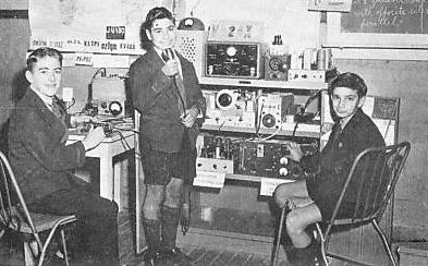
Australian boys' clothes were initially simply British clothes as Austrlalia was colonized by British settlers in the 19th century. The warmer Austrlalian climate necesitated some modifications, but clothing styles were esentially English until after World War II. This was especially true of dress clothes. Australian boys wore short pants and knee socks, some times even to 15 or 16, sometimes older if their school required a short pants uniform. Gradually Australians have developed their own styles. After the War, especially by the 1960s, Australian boys' clothes began to diverge more from English styles. The Australian climate and more easy going, casual life styles were important factor. The increasing American influence was probably another factor. Clothes are generally casual in Australia. School uniforms are still required at many schools, but styles have become increasingly casual. Since the 1970s, as in many other countries, jeans have become very popular with young people. Sun safe clothes have become important in recent years.
Germany proclaimed a protectorate over what at the time was called the New Britain Archipelago (1884). It was subsequently renamed the Bismarck Archipelago. The two principal islsands were New Britain and New Ireland whicvh the Germans also renamed. The Archipelao was located just to the north of the Solomon Islands. The Allies seized the islands during World War I. After Pearl Harbor, a string force of the Japanese attacked the islands, first bombing Rabaul fron Truk. Rabaul at the eastern tip of New Britain was the principal port in the Archipelago (January 1942). A substatial force of Japanese marines occupied both New Britain and New Ireland and smaller associated islands. The Allied campaign in the South Pacific Operation Cartwheel) centered on surounding and cutting off Rabaul. After the War, New Britain ad New Ireland became were eventually incorporated into Papua New Guina.
Brunei is a today a small Muslim kingdom located along the northern coast of Borneo on the South China Sea. Most of Brunei is lowland rain forests, but there are areas of mountain rain forest as well. Precipitation rates are very high. Brunei is the remnate of the powerful Sultanate of Brunei which was a major power in Oceania (15th-17th centuries). The Sultanate controlled an area extensing from extending from northern Borneo to the southern Philippines. The Brunei Sultans played a major role in spreading Islam into what is now the southern Philippines, Indonesia, and Borneo. The Portuguese seized Malacca (1511). This had been a major rival power. Eventually the Dutch and British split Borneo. Brunei became a British protectorate (1888). The Brunei Revoly against the monrchy was supressed with British help (1960s). Brunei decided not to join the Malaysian Federation, in part because of the Brunei Revolt (1963). The British granted independence (1984). The country has an important petroleum resource and, as a result, an extremely high standard of living.
The Cook Island archipelago consists of 15 small islands located in the South Pacific northeast of New Zealand about midway between New Xealand and Hawaii.. The Cook islanders are a Polyenesian people. Tradition credits Ru from Tupua'i in what is now French Polynesia with leading the first people to the islands. He landed on Aitutaki (about 800 AD). The Islands are of course named after Captain James Cook, who was the first European to site the Islands (1773). Europoean missiinaries converted some of the high chiefs who establishedca unified monarch (1858). The different islands in the group was united as the Kingdom of Rarotonga (1858). Britain at the request of Queen Makea, who was concerned about a French invasion, established a protectorate and created a federal parliament (1888). As New Zealand began to become a more independent Dominion, Britain transfrred authority for the Cook Islands (1901). The Islands were beyond the area conquered by the Japanese in World War II and thus escaped the damage expeienced by other South Pacific islands to the west. The Cook Islands today are a self-governing parliamentary democracy, freely associated with New Zealand. The climate is tropical moderated by trade winds. There is a dry season (April to November) and a more humid season (December to March). The terraine varies. The northern islands are low coral atolls. The southern islands are more hilly, volcanic in origin. There are no important natural resources. We have a Cook Island school page. We also have a page on Scouting, the only known youth group.
Fiji is a group of volcanic islands in the South Pacific lying between Vanuatu and Samoa. The principal island is Viti Levu. Melanesian and Polynesian peoples settled the Fijian islands about 1,500 BC. European traders and missionaries reached Fiji in the early 19th century. Conflicts led to wars among the native Fijian confederacies. Cakobau, a Ratu (chief), became the dominant force in the western islands (1850s). Continued conflict and unrest, however, convinced him and a convention of chiefs to accept British rule (1874). Under British rule, the countryside was pacified. Plantation agriculture was introduced and indentured workers were brought in from India. Traditional institutions, especially the system of communal land ownership, were maintained. A constitutional conference in London agreed that Fiji should become a fully sovereign and independent nation within the Commonwealth. Fiji became independent (1970). We do not yet have a Fiji page, but we do have a Fiji school page.
French Polynesia is an overseas country (pays d'outre-mer) of France. It consists of several groups of Polynesian islands in the South Pacific. Ffench Polynesia are some of the most easterly South Pacific Islands, located between American Samoa and Easter Islansd, the furthest eastern expansion of the Polynesian people. Polynesians first reached the Marquesas (300 AD). And then the Society Islands (800 AD). There was not central Polynesian state, but rather loose often warring chieftainships, but a recognition of a common culture. Portuguese explorer Ferdinand Magellan sighted Pukapuka in the Tuāmotu-Gambier Archipelago (1521). Dutch explorer Jakob Roggeveen encountered Bora Bora in the Society Islands (1722). British explorer Samuel Wallis landed on Tahiti (1767). French explorer Louis Antoine de Bougainville visited Tahiti (768). British navigator James Cook visited islands in the group (1769). Christian missions were established by Spanish Catholic priests who began work in Tahiti (1774). The London Missionary Society began working on the islnds (1797). The island groups that now comprise French Polynesia were not united in a political sense the French established a protectorate (1889). Colonial authorities on French Polynesia were among the first French colonial officials during World War II after the fall of France (June 1940) to afirm loyalty to the Free French who were committed to fight the Germans (1940 ). Many Polynesians served with French forces in the War. Soon after the fall of France, the Japanese Konoe Cabinet added French Polynesia among the many South Pacific island territories which were to added to the empire (September 1940). After the Japanese launched the Pacific War, they added many of the targeted islands to their Empire, but the U.S. Navy victory at Midway (June 1942) made it impossible to expand into the central Pacific. Thus French Polynesia remained beyond the range of Japanese expansion, but provided the U.S. Navy important rear area supply bases. The various islands are mostly small nd not well known. The best known island in French Polynesia is Tahiti in the Society Islands group. Tahiti is also the most populous island and the seat of the capital of the territory--Papeetē. Although not an integral part of FP, Clipperton Island was administered from French Polynesia until 2007.
|
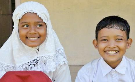
Indonesia is a huge country encompasing an emense archipelago. And it has one of the world's largest populations. This makes it the largest Muslim country in the world. Indonesia has had a turbulent history. The people were first influenced by Indian culture and the then Islamic traders. Finally the Portugese and Dutch reached the islands and colonized them (16th century). It was a prosperous Dutch colony. The Dutch introduced the rule of law and free market capitlism, but not democracy. The Dutch East Indies (DEI) were the Netherland's most important colony. The oil of the islands was the major objective of the Japanese military attack on Pearl Harbor. The DEI was devestated by the Japanese World War II occupation. The Nationalist movement dominated by the military that seized power after a brief war for independence introduced authoritarian rule and state socialism. The result was several decades of economic stagnation. The over throw of military rule has brought democracy and free market reforms that has brought unprecendented prosperity to the country. Boys' clothing in Indonesia has some similarity to neighboring Malaysia which also has a majority Islamic population. Some areas have a very mixed religious pattern: parts of Sumatra, Celebes, the Moluccas, have a Christian majority or large Christian minorities even among the non-Chinese population. Even on Java, which is predominantly Muslim, Roman Catholics may amount to up to 10 percent in some areas. Differences in dress among these groups, however, seems much less pronounced than in Malaysia. Islam, though requiring modesty, has never set rules as to the actual length of trousers, certainly not for men.
Kiribati was a British colony in the central Pacific know as the Gilbert Islands. It is composed of 32 atolls and a raised coral island, The atolls are spread out over 3.5 million square kilometres. Kiribati straddles the equator and borders the International Date Line at the eastern-most extension. British Captain Thomas Gilbert sighted the islands (1788). The Japanese seized the Islands after Pearl Harbor. The Japanese fortified the islands. When the U.S. Navy launched its central Pacific campign, the easterly located Gilberts were an early target. The Islands were the scene of a savage battle when the United States launched the Central Pacific campaign in the Gilberts. The caranage at Tarawa shocked Americans. The Gilbert and Ellice Islands gained self-rule (1971). They separated and were granted internal self-government (1975). Ellice Islands became the independent nation of Tuvalu (1978). The Gilbert Islands became independent as Kiribati (1979). The indigenous Gilbertese language name for the Gilbert Islands proper is "Tungaru". The new island state chose the name "Kiribati"--the Gilbertese pronunciation of "Gilberts" to acknowledge the inclusion of Banaba, the Line Islands, and the Phoenix Islands, which were never considered part of the Gilberts chain. We have a Kiribati schools page.
The Marianas islands are the most northerly part of the Micronesia island group. They were settled by Polynesians. The indugenous population is known as the Chamorros. The Marianas is an important archepeligo in rhe central Pacific. The Northern Marianas consists of 14 tropical islands stretching across 400 miles. They are adjacent to the Marianas trench which is the deepest point in the ocean. Saipan is the most populated island in the group. Rota is much less developed. The Northern Marianas were settled around 1500 BC by Chamorros who have cultural ties with the indigenous people on Guam. The pre-colonial population may have totaled 0.1 million peope, but was devestated by European diseases and misdtreatment at the hands of the Spanish. They were part of the Spanish colonial Empire, but Spain tokk only limited interest in them. The Spanish sold most of the islands to the Germans. The United States seized Guam in the Spanish-American War (1898). The Japanese seized the Islands from Germany during World War I and the League of Nations awarded the Japanese a trusteeeship. Because of tge suize of the islands, they were the focus of development efforts. The Japanese in particulrly focused on Saipan and large numbers of Japanese settled on the islands. The Islands were the scene of a bitterly fought World War II fighting. Th Japanese recognizedcthe importance of the islands. American possession of the Marianas brought the Home Islands within range of rapidly expanding strategic bomber force. The Japanese deployed the Imperial Fleet in an effort to stop the American landings. The American victory provided bases to begin an air campaign against the Japanese Home Islands. The current government of the Marianas is under a different jurisdiction from most of the rest of Micronesia which now consist of several independent countries. The Marianas Islands consiust of two U.S. jurisdictions: the territory of Guam and the Commonwealth of the Northern Mariana Islands.
The Marshall Islands is an island country located in the western Pacific Ocean jusdt north of the Equator, part of what is of Micronesia. The population is about 68,000 people living on more than 30 low-lying coral atolls. There are nearly 1,200 smallmislands and islets. The Marshalls share maritime boundaries with the Federated States of Micronesia to the west, Wake Island to the north, Kiribati to the south-east, and Nauru to the south. The most populous atoll is Majuro, where the capital is located. Micronesian colonists gradually settled the Marshalls and other neighboring islands as they developed advanced stick chrts for navigation (2nd millennium BC). , with inter-island navigation made possible using traditional stick charts. Spanish explorer Alonso de Salazar sighting the first atoll in the group (1526). The Marshalls were part of the German Pcoific rerritiries. Thgey were awarded to Japan as a League of Nstions mandate after World war I (1919). The Marsalls were the scene of bloody World War II fighting as the U.S. Navy began its Central Pacific Campaign The Gilberts were the first American target. Then came the Mrshalls (January-February 1944).
|
The Federated States of Micronesia (FSM) is located in the South Pacific just above the Equator northeast of New Guinea and south of the Marianas. The country consists of four member states: Chuuk (Truk Lagoon), Kosrae, Pohnpei, and Yap. Each of its four States is centered around one or more main high island, There are over 600 islands. The land area is very small (about 270 square miles), but the ocean area amounts to nearly 1 million square miles. The capital is Palikir, the largest city Kolonia, both on Pohnpei. The country was basically formed out of the Spanish colony of the Caroline Islands which in fact Spain made little effort to colonize. Germany purchased the islands (1899). Japan seized them during World War I (1914) and the League of Nations granted a trusteeship after the War (1920). Yap was an important communications center. The Japanese built a major base at Truk Lagoon. Truk and Rabaul to the south became the major forward operating bases for the Imperial Fleet during the opening phase of the Pacific War. The United States decided to bypass the Carolines as part of its Central Pacific offensive (1943-44), but rendered Truk impotent through devestating carrier attacks. The United States seized the islands from Japan after the Japanese surrender and administered them as a United Nations Trust Territories. The Unites States granted independence (1986/1994). We have some information on Micronesian education.
Nauru is located in the western Pacific, north of the Solomon Islands almost a squarely on the Equator. It was earlier known as Pleasant Island. Nauru is an uplifted coral formation. The population is primariy Micronesian and Polynesian totaling about 10,000 people. The initial Western presence was whalers using the island to resupply. A deadly tribal war followed which was only ended when Germany occupied the island (1888). The Germans developed the island's only important natural resource--phosphate. The Australians seized the island at the onset of World War I and after the War were granted a trusteeship by the League of Nations. The Japanese seized the island during the Pacific War (1942). Many of the men were forced into slave labor on the Caroline Islands. Nauru became a U.N. trusteeship (1947) and achieved its independence (1966). Nauru today is one of the smallest nations on earth, with a mostly Micronesian population Australia helped set up a refugee camp on the island. Economically Nauru is an example of a 'rentier state'. Nauru is essentialy a large phosphate rock. There are rich deposits of phosphate close to the surface which permit inexpensive strip mining. The nation is essentially digging itself up and exporting the escavated phosphate. We do not yet have much information on Nauru, but we do have a Nauru school page. Children during the early 20th century still wore traditional clothing.
New Caledonia is a French island group northeast of Austalia and south of the Solomons--a recipie for involvemnent in the Pacific War. New Caledonia is the third largest island in the Pacific after Papua New Guinea and New Zealand. It is surronded by crystal-claer largely unpopulted waters in the South Pacific. It is peopled by French settlers (some relted to convicts transported to the island) and the idigenous Melanesian people, called Kanaks. The British navigator James Cook encountered the islands (1774). He saw a similarity between the mountainous terrain of the Grande Terre and his native Scotland--historically known as Caledonia. The French annexed the island (1853). We do not yet have a page on the island. We do have some history pages on French colonial rule and the island's role in World War II. New Caledonia was an inportant staging and supply base for the Allies duing the fighting in the Solomons (1942-43). We also have a page on French colonial schools. There is liitle to say about the clothes the indigenous people wore. In the hot tropical climate, children rarely wore any clothing at all. Missionries when they arrive insisted that the natives wear at least some clothing. Today boys wear European-styled clothing suitable for tropical climate.
New Guinea is the second largest island in the world after Greenland. It is a rugged tropical island located just south of the Equator and north of Australia in the Southwest Pacific. For a long geological period was part of a land bridge connecting Australia with the Southeast Asian mainlznd. It was separated from Australia when when the area between the two landmasses was flooded after the warming phase of the last glacial period. This created the Torres Strait. The island was inhabited by primitive Stone Age with no centralized tribal organization. The first to arrive were the Dutch who wstablished trading posts in the west. The Europeans eventually partitioned the island in the late-9th century. The Netherland retained the western half. Germany claimed the northeast. Britain/Australia clained the southeat. The British znd Australians took over the German colony during World War I. The eastern half of the islsand was the location of an extended World War IIn campaign. The western half of the island today is the Indonesian provinces of Papua and West Papua. The eastern half and a number of offshore islands forms the mainland of independent Papua New Guinea.
|
New Zealand is located southeast of Australia in the south Pacific. The north-south orientation of the two main isalnds means that the country has wide climatic variation. New Zealand was settled by the seafaring Maori people around 1000 AD, one of the last places on earh to be peopled. The aborigees which people Australia, never reached New Zealand. Europeans became aware of New Zealand (7th century), but settlers did not begin arriving until much later (mid-19th century). A series of wars with the Maoris ensued until Europeans established control. Most of the original settlers were British and the islands was eventually annexed by the British. The economy was largely agricultural, but since World War II, Nw Zealand has developed a strong mixed economy. The Maori today are a substantial minority along with Pacific islanders. New Zealand boys clothing from the beginning of the colonial period in the 1840s followed mostly British styles. Often it is impossible to differentiate the two unless the photogrph is identified. The gernerally mild climate and low incomes in the colony meant that boys more commonly went barefoot. This also meant that long stockings were less common than in Britain. Boys commonly wore short pants through the 1950s. Long pants began to become more, except in secondary schools which generally required short pants school uniforms. Beginning in the World War II era (1939-45) America began to have an impact on boys' fashions. Large numbers of American troops began arriving shortly after Pearl Harbor (1942). The inability of Britain to defend Australia and New Zealand was a factor in a shifting of ties from primary links to Britain to a wider international outlook. New Zealand boys' fashions had become similar to those worn in Europe and America, with the exception of school uniforms (1980s). Improving economic conditions were a factor here. The same trends were at play in Australia.
The Republic of Palau is a Pacific island nation 500 miles east of the Philippine Islands. Palau is a small oceanic archepelago. The larger islands are Angaur, Babeldaob, Koror, and Peleliu. The latter three lie close together within the same barrier reef, Angaur is an oceanic island several miles to the south. Most of the population live on Koror. The small coral atoll of Kayangel is located north of the other islands. There is also uninhabited Rock Islands to the west of the rest of Palau. And a remote group of six small islands, the Southwest Islands, some 375 miles from the main islands are the final piece of the country. Palau became important in World War II because of its location. The United States in preparation for the invasion of the Philippines, attacked Peleliu (1944). A horendous battle ensued in the rugged terraine of the island where the Japanese were well entrenched. After the WAr, the United Statyes administerted Palau as a United Nations Trusteeship. The U.N. granted Palau independebce (1994).
A Filipina (this is the Tagalog spelling and there's no English one) reader tells us that clothing styles have been affected by the Spanish which ruled the islands for three centuries. Traditional clothing for boys was baro and for girls saya. America which seized the Philippines from Spain (1898) also influenced fashion. The Japanese which occupied the country (1942-45) during World war II had less influence. The Philippines became independent after the War (1948). Our Filipina reader writes, "Currently we wear what Americans wear. But I have to admit I believe that we are more modest than the Americans because we are more concious about how much skin we show, due to our religion. Also the climate is very warm and sometimes very rainy, we wear what suits the climate. While we do not yet have a Philippines page, we do have a page on First Communion. We also have pages on Filipino school uniforms and Filipino Scouts.
Pitcairn Island may be among the most isolated places on earth. Pitcairn is the Pacific island where in 1790 the Bounty's mutineers landed. Fletcher Christian led the mutineers to this remote island, was a son of the Coroner of Cumberland and of Manx descent on his father's side. He is still remembered as the founder and first leader of the settlement. By 1800 John Adams was the only male survivor of the party that had landed just 10 years before. The community was made up of ten Polynesian women and twenty-three children. In 1808 the little colony was discovered by Captain Mayhew Folger, an American sealing captain, but his visit was brief. The HMS Briton and Tagus rediscovered the settlement 6 years later on September 17, 1814. All the Pitcairn inhabitants joined Seventh Day Adventist Church (1887).
The Samoan Islands in the South Pacific are of volcanic origins. Theywere first called Navigators Islands because of the Samoans' reputarion as seafarers. They resisted European colonization until the end of the 19th century. The Samoan Islands were split betwwen the United States and Germany (1900). The modern independent state of Samoais tghe Western Samoan Islands. The Eastern Islands are an United States dependemncy. The Western Islands were seized by the Allies in the opening months of World War I and the League of Nations granted a trusreeship to New Zealand. The Island were beyond the reach of the Japanese offensive in the early months of the World War II Pacific War. New Zealand granted independence (1962). Samoa continues to maintain close ties with New Zealand and quite a number have migtated to New Zealand looking for jobs. The two principal islands are Upolu and Savai'i. Savai'i is one of the largest Polynesian islands. The capital city Apia is located on Upolu.
The polpulation is nearly 0.2 million people. More than 90 percent are Polynesian. Only the Maoris on New Zealand out number the Samoans in the South Pacific. Most of the rest of the population is Euronesians (mixed European and Polynesian ancestry). Most of the population (about 75 percent) lives on Upolu. Most Samoans are Christian divided among several major denomintions.
The Solomons located just east of New Guinea were virtually unknown before World War II. They are a twin chain of volcanic islands streaching 900 miles in a parallel arangement north and south. The water area between the two chains came to be called the Slot. The volcanic islands are mounatenous and heavily covered with tropical vegetation. There are also small coral atols. There are about 1,000 islands and atolls. The population is primarily Melanesian (93 percent. The remainder is Polynesian, Micronesian, and other. Most of the population is Christian, divided into many different demominations: Anglican (Archdiocese of Melanesia), Roman Catholic, South Sea Evangelical, United Church (Methodist), Seventh-day Adventist. The principsal language is English in part because a common lsngusge was needed. There are many vernacular languageds, including Solomon Islands pidgin. The major islands include the British Protectorates of Guadacanal, Malaita, New Georgia, Santa Cruz Isles (group), Choiseul, Santa Isabel, San Cristobal, and Shortland. The Santa Cruz Islands are an outlier, well to the eadt of the rest of the Sollomons. Bougainville and Buka in the north were administered by Australia as a part of the New Guinea Mandate. The main exports were copra and timber. The Solomons had few resources. What they did have was a strategic location. As a result, some of the critical battles of the Pacific War were fought in the Sollomons.
The Kingdom of Tonga is an archipelago of 176 small islands (about 50 of which are inhabited) scattered over a vast area of the South Pacific. The capital is Nuku'alofa which is located on Tongatapu, the lasrgest islasnd. Here the King, the Government, and interesting archaeological sites. Tonga is located to the south of Samoa and east of Fiji. There are three main groups--Vava'u, Ha'apai, and Tongatapu. The various islands include two types. Most have a limestone base and were formed geologically from uplifted ocean coral formations. Others islands have a limestone base over an old volcanic base. The climate is subtropical with a distinct warm period (December-April) and a cooler period (May-November). The annual rainfall increases substantially as one moves from Tongatapu in the south to the more northerly islands closer to the Equator. The Tongans are a Polynesian group with a very small mixture of Melanesian. There are a few European, mixed European, other Pacific Islanders, and Chinese. We do not yet have a Tongan page. We do have a Tongan school page.
Tuvalu is a Polynesian island nation located in the South Pacific Ocean, approximately midway between Hawaii and Australia. Its nearest neighbours are island nations of Kiribati, Nauru, Samoa and Fiji. The islands are atols with very limited populations and land areas.
The Islands were administered by Britain as part of a protectorate (1892-1916) and as part of the Gilbert and Ellice Islands Colony (1916-74). The Ellice Islanders voted for separate British dependency status as Tuvalu (1974).
The Gilbert Islands became the independent country of Kiribati. Tuvalu became fully independent within the Commonwealth (1978). We have very limited information on Tuvaly. We do have a Scouting page.
Vanuatu is located east of northgern Austrlia and south of the Solomons. The islands were settled by melanesian people sailing south from the Solomon Islands and Papua New Guinea (about 1500 BC). The first Europeans to site the islands was Portuguese navigator Pedro Fernandes de Queiros (1606). The waters around the islands were British explorwr James Cook (1774). He named the archipelago New Hebrides because they reminded him of Scottish islands. Missinaries arrived (19th centurt). The islands were unclaimed by Europeans until the 20th century. The British and French agreed to a condominium government (1906). There were both British and French settlers with the French predominating. The New Hebredes during World War II were an important supply and stagiung area for the Allied South Pacific offesive in Guadacanal and the rest of the Solomons. Major naval engagements were fought north of the islands. An independence movement gained strength (1970s). The islands became independent as the Republic of Vanuatu (1980). The population is lsargely rural, although Port Vila and Luganville have grown in population. The Vanuatu population (Ni-Vanuatu) are mostly Melanesian with a few Europeans, Asians and other Pacific islanders. We do not yet have a page on Vanuatu, but we do have a schools page.
Breward, I. Christianity in Polynesia: Transforming the Islands,” in ed. C. Farhadian, Introducing World Christianity (Oxford: Blackwell, 2012), pp. 218–29.
Garrett, J. Footsteps in the Sea: Christianity in Oceania to World War II (Geneva: World Council of Churches; Suva: Institute of Pacific, 1992).
Trompf, G.W. (2012) “Christianity in Melanesia: Transforming the Warrior Spirit,” in C. Farhadian, ed.
Introducing World Christianity (244–258. Oxford: Blackwell, 2012), pp.244-58.

Navigate the Boys' Historical Clothing Web Site:
[Return to the Main Oceania page]
[Return to the Main country page]
[Introduction]
[Activities]
[Biographies]
[Chronology]
[Clothing styles]
[Countries]
[Bibliographies]
[Contributions]
[FAQs]
[Glossaries]
[Images]
[Links]
[Registration]
[Tools]
[Boys' Clothing Home]