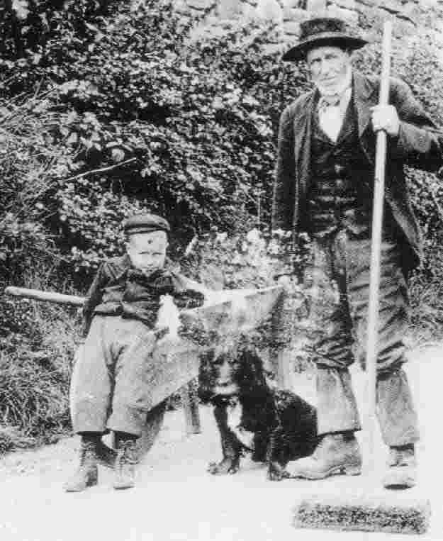
Figure 1.--Lacaster contains two of England's largest cities, Liverpool and Manchester, as well as many charming small villages. This portrait was taken in Halton-on-Lune Village. A HBC reader tells us, "The street sweeper is Sam Lambert , my husband's grandfather's uncle, from Halton Village in Lancashire. The photo was taken in 1908 and we have it on our website. We are researching his family in England and are looking for the Lambert family in England. He had a brother named James Lambert (who's wife was Jane) (my husband's great grandfather) and a brother named John Lambert. They all lived in Halton." -- Barbara Lambert. To see Barbara's website, which includes a Lambert geneaology section, click on the image.
The nations comprising Britain as a whole are covered under the United Kingdom. But England itself has several different counties such as Chesire, Corwall, Devon, Kent, Lancaster, Norfolk, Surrey, Yorkshire, and others. Just how these counties are grouped together has varied over time. We notice countless different regional groupings. There is no defintive system. We have just begun to collect information on these different counties. There is, however, already quite a bit of information about these various counties on different HBC pages, many of which are not yet linked here. The speaking of Corish died out in the 18th century, but there is some attempt to teach a little in the schools. Many Americans were introduced to Yorkshire by the marvelous James Herriot books and TV programs. Often life in Medieval England centered around the great cathedrals that were built in the different counties. Many of our English choir pages have information about the cathedrals and Medieval life. Readers from many English counties have provided HBC accounts of their childhoods. Our account here is somewhat complicatedby the fact that the English Government has changed the boundaries of several counties, incliding Durham, Tyne and Wear, and Yorkshire and as well created new counties such as Cumbria. Hopefully our British readers will provide us additional information about the different counties as HBC develops.
We have begun to develop some information on the Channel Islands located off the French coast at Normandy. The French refer to them as Iles Normandes. The main islands are: Jersey, Guernsey, Aldernay, Sark, and Herm. The islands were part of the patrimony of the Dukes of Normandy and after Duke Willian conquered England (1066), the islands have been controlled by England rather than France. The two largest are Gernsey and Jersey. The islands have two administrative districts. Jersey has about half the total population. The main town is St. Helier. We have some information on Jersey. The other administrative distruct is Guernsey and all the other islands. Enlisg gradually replaced French as the official language. The climate provided rich pasttures and as a result the economies were largely pastoral, both sheep and cow. As a result of the sheep and weaving industry there, the term jersey has passed into the English language as a clothing term. The islands are also well known for tghe cattle breeds develped there.
The Isle of Man is located in the Irish Sea between England and Ireland. The island has been held by Norway (as a result of Viking raids), Scotland, and the earlys of Derby and Salisbury. I came under the control of the British Crown during the 1820s. The island has its own separate legislature. The inhabitants once spoke Manx, one of the Celtic languages. It is today little spoken. The capital is Douglas. The economy has traditionally been largely agrcultural with some guarying. The mild climate has heloped to make tourism a major part of the economy. Prince Albert built Queen Victoria a residence on the Isle of Wright--Osborne House near East Cowes. Here she and the growing public could relax out of the public splotlight.
The Isles of Scilly is an archipelago off the southwestern tip of Cornwall out into the Atlanric. The islands used to be one large island. St. Agnes is the most easterly and southerly point in England. The island are east of kand's End in Cornwall. This is also over 4 miles further south than the most southerly point of the British mainland -- Lizard Point.There has since ancient times been a small population. The islands are mostly assocuated with Cornwall. Historically, the economy included kelp harvesting, pilotage, smuggling, fishing, and shipbuilding. The modern econimy is based on tourism and cut flowers. The islands have had a fascinating history. They were visited bt the POhiecians and Greekls in ancuent time. Lrobabky the amjor ujnterest was Coirnish tin. Then there were Viking raids slave trading raids by the barbary Pirates. Then there was a 350-year war with the Dutch. The islands were the location of one of the Royal Navy's worst disaters. A fleet of 21 Royal Navy ships sailing from from Gibraltar to Portsmouth ran nito the islands. Six ships were driven onto the rock cliffs. Four were sunk or capsized, some 1,450 sailors were killed. Amoing the deaf were Admiral Sir Cloudesley Shovell.
Kent is the southeast corner of England and one of the Home Counties--,eaning the counties surrounding Lonson. Greater London is located to the northwest, Surrey to the west, East Sussex to the southwest, and north across the Thames Estuary is Essex. The county town is Maidstone. England was essentially born around Kent. After the departure of the Romans, came the Anglo-Saxon incursions. The primary group in Kent was the Jutes. Not only does Kent border on London, but
but it was here that Saint Augustine led the Anglo-Saxon conversion to Christainity. The Kent Kingdom was one of the most important Anglo-Saxon Kingdoms and the first to convert (6th century AD). Canterbury Cathedral in Kent has been the seat of the Archbishop of Canterbury, leader of the Church of England. Both London and Canterbury played a key role in English Christianity and the Enlish language and ultimatly the English nation.
France can be seen clearly in fine weather from Folkestone and the famous White Cliffs of Dover--where England begins. Hills in the form of the North Downs and the Greensand Ridge run the length of Kent and in the valleys in between and to the south are most of the county's 26 medievel castles. The Strait of Dover in the South is the closest connection with Europe (France) also leading to Kent's place in English history. Ports in Kent have played an important role in the development of Royal Navy. The Cinque Ports (12th�14th centuries) and the Chatham Dockyard (16th�20th centuries) were epecially notable. During World War II, the first desperate phase of the Battle of Britain was fought in the skies over Kent. Large areas of Kent are suitable for agriculture which is what drew the Anglo-Saxons. Even today, the abundance of fruit-growing and hop gardens has led to Kent becoming known as 'The Garden of England'. There were also coal mines during the industrial revolution.
A HBC reader tells us about his boyhood growing up in Kent. He says, "My family was thrifty,working class. My mum did not work and so was at home all the time to look after us. As a boy growing up during the early 1950s in southeastern England (Kent). I don't remember being clothes conscious. In fact I don't think boys in general gave a great deal of thought to clothes, unlike boys today."
Surrey
Greater London
London is the largest and most cosmopolitan city in Britain. London or Londinium was a Roman creation, chosen as the best point to cross the Thames, linking northern England with the Channel seaports to the South. It was the Romans who built the first bridge over the Thames. The Medieval London Bridge was one of the jewels of English civilization. London has several cathedrals and cathedral choirs, including St Pauls, Westminister Abbey, and Westminister Cathedral which have played major roles in the life of the city. London today is best known as the location of Westminister Abby, the House of Parliament, Buckingham Palace and the Tower of London. An image taken in he 1950s ia available, but we are not sure just where in London that it was taken. A HBC reader remembers growing up in East London during the 1960s. Many people around the world have come to know London and londoners through the BBC TV program "Eastenders"
Southwest
Cornwall
Corwall is located at the far southwestern tip of England. It is perhaps most noted for Land's End. In Roman times it was famous for its tin mines. The speaking of Corish died out in the 18th century, but there is some attempt to teach a little in the schools. We have a wondeful image of a Cornish village school.
Devonshire
Devonshire or Devon is a county in southwest England located between Briston and the Channel. The Welsh population of Devon was conquered by invading Anglo Saxons in the 8th century who were then conquuered by the Normans in the 11th century. The Channel coast towns of Devon were attacked by the French during the 14th and 15th centuries. Plymouth became a major Royal Navy port. Plymoyth was heavily bombed by the Lufwaffe during World War II. The northern coast is two bays, the outlet of the Rivers Taw and Barnsatable. The southern coast is largely made up of clifts. The most notable feature of the county is dartmoor, granite tableland. The Devonian Era or the Age of the Fishes is named after Devon because rock formation from this era werre first studied in Devon during the 1840s. Devon is an important agriculture area with the cultivation of oats and the development of fruit orchards. Devon is also an important dairy producer in England. Anyone visiting England should have at least one Devon cream tea with artery clogging clotted cream of course. The relatively mild climate has resulted in the founding of many resort towns. The capital is Exeter and the largest city is Plymouth, notable for both fisheries and the Royal Navy base as well as another base at Devon port. Plymouth is where the Mayflower that founded the Plymouth Colony (Massachusetts) sailed from. We have an interesting image of onion sellers in Plymouth during 1907.
Dorset
A HBC reader remembers growing up in Dorset during the 1950s and 60s.
Industrial Midlands
Chesire
We are unsure why Lewids Carol in Alice in Wonderland named the cat after Chesire. We do know that Carrol or Charles Dogworth was born in Cheshire.
Derbyshire
Derbyshire is the location of Subbury Hall one of England's great stately homes and which includes a children's museum.
Durham is a northeastern country near Scotland and facing the North Sea. Modern Durham was after the Norse invasions (9th century) located withon the Dane Law. The name "Durham" interestingly comes from a fusion of Old English and Old Norsecomes. The Old English "dun" meant hill and the Old Norse "holme" meant island. And the center of Durham city was a bend in the River Wear nearly creating an island. Dun Cow Lane was said to be on of the first city streets and it was here that the the monks of Lindisfarne carried the body of Saint Cuthbert (955 AD). The imposing Norman castel and cathedral were built on a hill within the bend of the river. As a result it dominates the countryside for miles around. Durham and Durham Castel was a Royalist stringhold during the Civil war. Durham was important during the Industrial revolution. The city saw the creation of the world�s first passenger railway (1825). Important coal fields were located in the county and coalbecame the county�s main industry until the 1970s. Virtually every village around the city had a coal mine. A HBC reader tells us that he was born in what was County Durham, but in 1974 thanks to local government reorganisation, the town I live in became part of the metropolitan county of Tyne and Wear.
Lancashire is a maritime county of northwestern England. The county seat is Lancaster, but the county includes two of England's greatest cities, Liverpool and Manchester. The coastal in Lanshire is wide and low hills rise in the east and north. The county is bisected by Morecambe Bay. The hills of the northern section extend into England's lovely Lake District. There are two principal rivers, the Mersey (separating Lancashire from Chesire to the south) and the Ribble. Lacashire played a major role in the Industrial Revolution. Lancashire was a center of the British coal mining industry and a huge coal field is located between the two rivers. There is also iron ore. Barrow in Furness is the loication of one of the largest steel mills in England. As Lancaster was heavily industrialized it was an important target in the World War II Blitz. Manchester in the south was the site of the greatest cotton manufacturing centers in the world. It was the manufacture of textiles in Manchester and other cities that propelled Engkand into the Industrial Revolution. Other important induustries are glass, watches, soap, and machinery. Liverpool is one of England's most important ports and of course famous as the birth place for the Beatles. Agricultural production is Lancashire is limited. Mant of the rural villages of the19th century have become bedroom commuunities for Liverpool and Manchester. One HBC reader has provided us some images from his Lancaster village. He writes, "I thought I would share with you some images from my village Halton-on-Lune near Lancaster which show the type of clothing worn between 1880 and 1940. You will no doubt spot a number of flat caps and clogs!" A HBC reader has provided us some information about Blackburn, another industrial city in Lancaster during the 1950s and 60s. He tells us, "My home town is Blackburn, Lancashire, U.K. It was a town made famous by the Beatles. They wrote a song that told about the number of roads being repaird in the town. The words were misinterpreted in America as meaning the needle punctures in a drug addicts arm! The town newspaper's poked fun at America for some considerable time and the readership joined in the joke! The town football team is Blackburn Rovers."
The far north of England borders on Scotland. The beautiful Lake District is located in the far north with some of England's most rugged mountains. The highest point in the northeast is The Cheviot, in Northumberland, at 815m. The largest city is Newcastle. Sunderland is the second-largest. Its natural beauty can be found in Northumberland National Park. It has a beautiful North Sea coastline There is a section of the Pennines and Weardale. It also has great historic importance. There are two World Heritage Sites: Durham Cathedral and Hadrian's Wall which cuts across the island. The far north is a largely agricultural area with some industrial cities in Yorkshire. It is less densly populted than southern England.
Sources
Barbara Lambert, E-mail message, September 8, 2003.