
Greek Regions--Aegean Islands
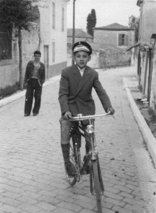
Figure 1.--Here we see a boy from Mytilini, the capital of Lesbos, one of the northeastern Aegean Island. Lesbos was governed by the Ottoman Empire for centuries until being returned to Greece after World War I. This photograph looks to have been taken about 1930, shortly after the transition to Greek rule. I'm not sure what kind of cap he is wearing.
|
|
The Aegean Islands are a diverse group of islands in the Aegean Sea between mainland Greece on the west and north and Turkey on the east and Crete to the south. The ancient Greek name for the Aegean Sea was Archipelago (ἀρχιπέλαγος) which gradually became the term used for the islands in the Aegean. Over time it has become the the general term for an island group. The history of the islands varies. The were part of Hellenic Greece and then part of the Roman Empire. After the fall of Rome, they were controlled by first the Byzantine Empire and then a variety of different powers including Venice, the Papacy, the Normans, Genoa, the Ottoman Empire, Fascist Italy, NAZI Germany, and other lesser powers. This varied from island to island. Each individual island has its own fascinating story. The Aegean Islands since the First Balkan War (with an Italian/German World War II interlude) have primarily been Greek. The Italians acquired some of the islands after the Italo-Turkish War (1912)--the Dodecanese, including Rhodes and Kastelorizo. They were returned to Greece after World War II. Mussolinmi had attempted to Romanize the populations, but the islands remain largely Greek. Turkey has a few islands in the northeast (Imbros and Tenados) as well as various smaller islets along the country's coast. The Greek Aegean Islands are traditionally divided into seven groups: Northeastern Aegean (Thasos, Limnos, Lesbos, Chios, Icaria, and Samos), Sporades, Euboea, Argo-Saronic Islands, Cyclades, the Dodecanese (with some exceptions), and Crete.
Geography
The Aegean Islands are a diverse group of generally islands in the Aegean Sea between mainland Greece on the west and north and Turkey on the east and Crete to the south. The ancient Greek name for the Aegean Sea was Archipelago (ἀρχιπέλαγος) which gradually became the term used for the islands in the Aegean. Over time it has become the general term for any island group.
History
The history of the islands varies. The were part of Hellenic Greece and then part of the Roman Empire. After the fall of Rome, they were controlled by first the Byzantine Empire and then a variety of different powers including Venice, the Papacy, the Normans, Genoa, the Ottoman Empire, Fascist Italy, NAZI Germany, and other lesser powers. This varied from island to island. Each individual island has its own fascinating story. The Aegean Islands since the First Balkan War (with an Italian/German World War II interlude) have primarily been Greek. The Italians acquired some of the islands after the Italo-Turkish War (1912)--the Dodecanese, including Rhodes and Kastelorizo. A World War II battle was fought over the Dodecanese by the British and German. It was a rare instance that the British after America entered the War decided to go it alone. It did not go well for them.
The Italian-occupied islands were returned to Greece after World War II. Mussolinmi had attempted to Romanize the populations, but the islands remain largely Greek. Turkey has a few islands in the northeast (Imbros and Tenados) as well as various smaller islets along the country's coast.
Aegean Sea
The Aegean Sea (Aigaíon Pélagos/Ege Deniz) is the northeaster arm of the Mediterranean Sea leading to the Dardanelles and Bosporus and into the Black Sea. It is this of coniderable importance at the dawn of Europeam
Civilization. It is located between the Greek peninsula on the west and Asia Minor (Anatolia) on the east. It is about 380 miles (612 km) long and 186 miles (299 km) wide with a total area of some 83,000 square miles (215,000 square km). The relatively small area dotted with countless island was thus the perfect environment for the Greeks developing early sea-going technology. The island of Crete separates the argean from the g its boundary on the south. The cradle of two of the great early civilizations, those of Crete and Greece, from the Mediterranean. This is of course the bcradel from with clasical Western Civilization emerged. The Aegean has been described asa bay within the eastern Mediterranean basin. There are connections through the straits to the west and east of Crete. There is also a connection to the Ionian Sea to the west, through the strait lying between the Peloponnese peninsula of Greece and Crete.
Major Island Groups
The Greek Aegean Islands are traditionally divided into seven groups: Northeastern Aegean (Thasos, Limnos, Lesbos, Chios, Icaria, and Samos), Sporades, Euboea, Argo-Saronic Islands, Cyclades, the Dodecanese (with some exceptions), and Crete. The Aegean is virtually stunning, numerous islands large and small emerge from the clear blue waters. These are the mountain peaks of Aegeis, the name given to a now-submerged landmass. At the dawn of European history, these islands facilitated contacts between the people of the area and of three continents. Poor soil ha limited settlement of the island. In modern times the raw beauty of the deep blue Argean and brilliant white villages draws tourists to the island creating a level of prospaerity never previously known except on Crete .
Northheastern Aegean Thasos
The Northeastern Aegean includes Thasos, Limnos, Lesbos, Chios, Icaria, and Samos.
Sporades
Eubboea
Argo-Saronic Islands
The Cyclades or Circukar Islands are located in the southern Aegean Sea, southeast of mainland Greece. They dominate the southern Aegenian north of Crete. They are a forrmer administrative prefecture of Greece. Cyclades refers to the islands which form a circle around the sacred island of Delos. The largest island of the Cyclades is Naxos. The Cyclades comprise about 220 islands, most being small uninhabited islets of little importance. The major islands are all small, including Amorgos, Anafi, Andros, Antiparos, Delos, Ios, Kea, Kimolos, Kythnos, Milos, Mykonos, Naxos, Paros, Folegandros, Serifos, Sifnos, Sikinos, Syros, Tinos, and Thira or Santoríni.
Ermoupoli on Syros is the chief town and administrative center of the former prefecture. Geologically the islands are peaks of a submerged mountainous terrain. The primary exception are the two volcanic islands, Milos and Santorini. Besides Delos, Santorini was the site of one of the largest volcanic eruptions in recorded history--sometimes called the Thera eruption. It occurred about 3,600 years ago, notably the height of the Minoan civilization. The eruption left a large caldera which can be observed today. It is surrounded by volcanic ash deposits hundreds of metres deep. Many historians believe it may have led indirectly to the collapse of the Minoan civilization on Crete. The climate of these island is generally dry and mild, but with sole exception of Naxos the soil on these iallands is rocky amd not very fertile which limits the population that can be supported. The agricultural that does exist is similar to that of mainland Greece, mostly for grapes (wine production), fruit, wheat, olive (oil prouction), and im nodern times tobacco. Somewhat cooler temperatures are noted in in higher elevations. The islands experience very mild winters as a result of the warm Aegean waters. There are no islands to the south in between the Cyclades and Crete in the Sea of Crete.
The Dodecanese
The Dodecanese are located to the east of the Cyclades in the southern Agean along the Turkish (Anatolian) coast.
We have little information on Crete, a large elongated Medditeranean island south of the mainland. Crete is the largest of the Greek islands. It marks the southern limits of the Aegean Sea. It is divided into four prefectures: Chania, Heraklion, Lassithi and Rethymno. Much of the island is rugged and mountainous. The coastline is notable for beautiful beaches and rocky coves which now attract tourists who also enjoy charming villages. Crete was the birthplace of famed Minoan civilization and many believe to be the cradle of Greek culture. Santorini to the north is another important Minoan island. The at Knossos are the best preserved of the Minoan Civilization. The noted Swiss photographer Fred Boissonnas traveled around Greece and photographed almost all it's regions. One photoraph shows the Mandaka family. A HBC reader reports, "I have seen other photos by Boissonnas of the family in photo expositions. I believe that it was a big and wealthy family.
HBC

Navigate the Boys' Historical Clothing Web Site:
[Introduction]
[Activities]
[Biographies]
[Chronology]
[Clothing styles]
[Countries]
[Bibliographies]
[Contributions]
[FAQs]
[Glossaries]
[Images]
[Links]
[Registration]
[Tools]
[Boys' Clothing Home]
Navigate the Boys' Historical Clothing Belgin pages:
[Return to the Main Greek regional page]
[Greek choirs]
[Greek folk costumes]
[Greek movies]
[Greek royals]
[Greek schools]
[Greek youth groups]
Created: 9:41 PM 10/14/2011
Last updated: 6:41 PM 3/26/2019